You are here: Home > Network List > TA - USArray Transportable Network (new EarthScope stations) Stations List
> Station J22A Midwest, WY, USA > Earthquake Result Viewer
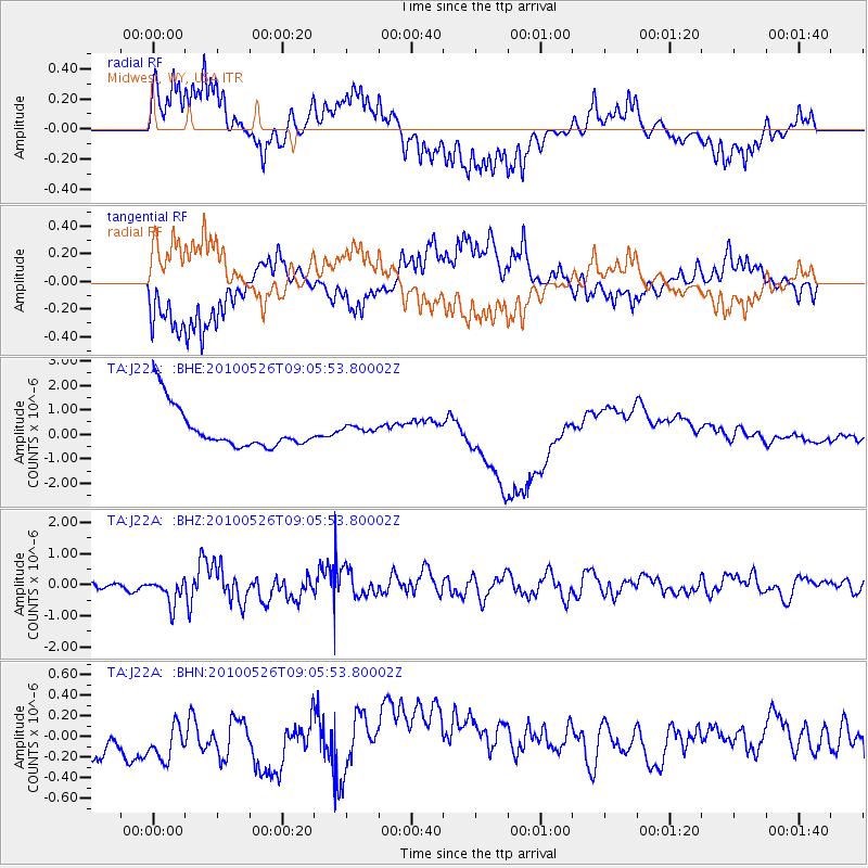
J22A Midwest, WY, USA - Earthquake Result Viewer
*The percent match for this event was below the threshold and hence no stack was calculated.
| Earthquake location: |
Southeast Of Ryukyu Islands |
| Earthquake latitude/longitude: |
25.8/129.9 |
| Earthquake time(UTC): |
2010/05/26 (146) 08:53:08 GMT |
| Earthquake Depth: |
10 km |
| Earthquake Magnitude: |
6.2 MB, 6.2 MS, 6.5 MW, 6.5 MW |
| Earthquake Catalog/Contributor: |
WHDF/NEIC |
|
| Network: |
TA USArray Transportable Network (new EarthScope stations) |
| Station: |
J22A Midwest, WY, USA |
| Lat/Lon: |
43.41 N/106.48 W |
| Elevation: |
1587 m |
|
| Distance: |
93.9 deg |
| Az: |
37.482 deg |
| Baz: |
311.157 deg |
| Ray Param: |
$rayparam |
*The percent match for this event was below the threshold and hence was not used in the summary stack. |
|
| Radial Match: |
46.25331 % |
| Radial Bump: |
287 |
| Transverse Match: |
44.413517 % |
| Transverse Bump: |
343 |
| SOD ConfigId: |
314592 |
| Insert Time: |
2010-09-14 07:06:01.807 +0000 |
| GWidth: |
2.5 |
| Max Bumps: |
400 |
| Tol: |
0.001 |
|
Signal To Noise
| Channel | StoN | STA | LTA |
| TA:J22A: :BHZ:20100526T09:05:53.80002Z | 3.0252454 | 4.563564E-7 | 1.5084939E-7 |
| TA:J22A: :BHN:20100526T09:05:53.80002Z | 0.9923339 | 2.3491266E-7 | 2.3672743E-7 |
| TA:J22A: :BHE:20100526T09:05:53.80002Z | 0.17634876 | 1.4974874E-7 | 8.4916246E-7 |
| Arrivals |
| Ps | |
| PpPs | |
| PsPs/PpSs | |


