You are here: Home > Network List > AV - Alaska Volcano Observatory Stations List
> Station ACH Angle Creek Headwaters, Katmai, Alaska > Earthquake Result Viewer
ACH Angle Creek Headwaters, Katmai, Alaska - Earthquake Result Viewer
| Earthquake location: |
Tonga Islands |
| Earthquake latitude/longitude: |
-17.9/-174.7 |
| Earthquake time(UTC): |
2023/07/02 (183) 10:27:45 GMT |
| Earthquake Depth: |
247 km |
| Earthquake Magnitude: |
6.7 Mi |
| Earthquake Catalog/Contributor: |
NEIC PDE/at |
|
| Network: |
AV Alaska Volcano Observatory |
| Station: |
ACH Angle Creek Headwaters, Katmai, Alaska |
| Lat/Lon: |
58.21 N/155.33 W |
| Elevation: |
960 m |
|
| Distance: |
77.5 deg |
| Az: |
10.361 deg |
| Baz: |
198.875 deg |
| Ray Param: |
0.049625613 |
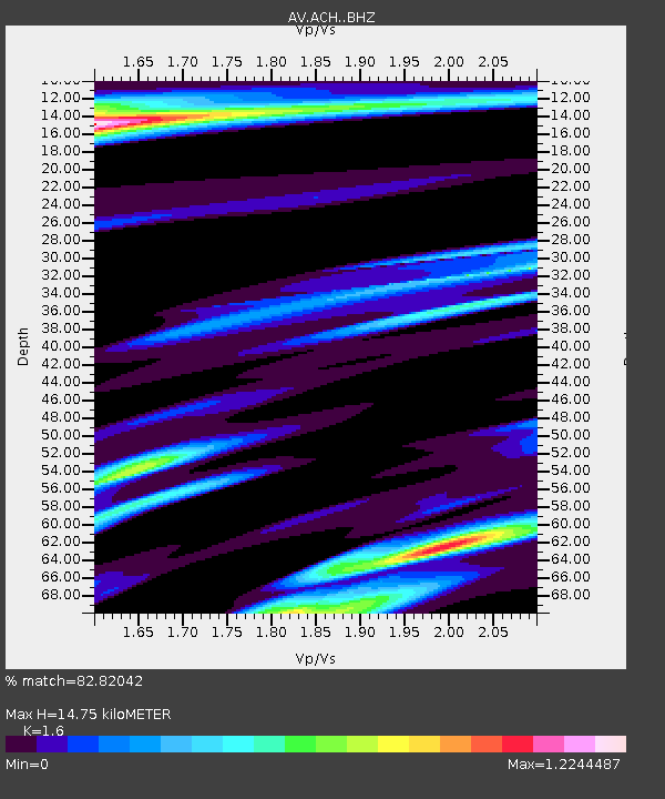
| Estimated Moho Depth: |
14.75 km |
| Estimated Crust Vp/Vs: |
1.60 |
| Assumed Crust Vp: |
6.438 km/s |
| Estimated Crust Vs: |
4.024 km/s |
| Estimated Crust Poisson's Ratio: |
0.18 |
|
| Radial Match: |
82.82042 % |
| Radial Bump: |
400 |
| Transverse Match: |
52.311886 % |
| Transverse Bump: |
400 |
| SOD ConfigId: |
30536071 |
| Insert Time: |
2023-07-16 10:36:03.048 +0000 |
| GWidth: |
2.5 |
| Max Bumps: |
400 |
| Tol: |
0.001 |
|

Signal To Noise
| Channel | StoN | STA | LTA |
| AV:ACH: :BHZ:20230702T10:38:42.228027Z | 8.320741 | 3.4704333E-6 | 4.1708228E-7 |
| AV:ACH: :BHN:20230702T10:38:42.228027Z | 2.820987 | 2.031396E-6 | 7.201011E-7 |
| AV:ACH: :BHE:20230702T10:38:42.228027Z | 0.6751763 | 1.2006354E-6 | 1.7782547E-6 |
| Arrivals |
| Ps | 1.4 SECOND |
| PpPs | 5.8 SECOND |
| PsPs/PpSs | 7.2 SECOND |


