You are here: Home > Network List > AV - Alaska Volcano Observatory Stations List
> Station CEAP Anvil Peak, Cerberus Volcano, Alaska > Earthquake Result Viewer
CEAP Anvil Peak, Cerberus Volcano, Alaska - Earthquake Result Viewer
| Earthquake location: |
Tonga Islands |
| Earthquake latitude/longitude: |
-17.9/-174.7 |
| Earthquake time(UTC): |
2023/07/02 (183) 10:27:45 GMT |
| Earthquake Depth: |
247 km |
| Earthquake Magnitude: |
6.7 Mi |
| Earthquake Catalog/Contributor: |
NEIC PDE/at |
|
| Network: |
AV Alaska Volcano Observatory |
| Station: |
CEAP Anvil Peak, Cerberus Volcano, Alaska |
| Lat/Lon: |
52.00 N/179.58 E |
| Elevation: |
244 m |
|
| Distance: |
69.8 deg |
| Az: |
356.232 deg |
| Baz: |
174.191 deg |
| Ray Param: |
0.05470877 |
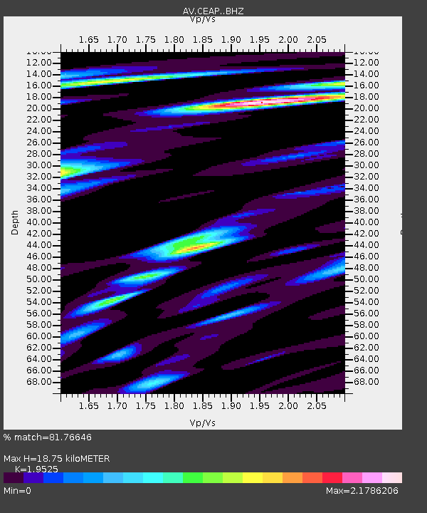
| Estimated Moho Depth: |
18.75 km |
| Estimated Crust Vp/Vs: |
1.95 |
| Assumed Crust Vp: |
6.183 km/s |
| Estimated Crust Vs: |
3.167 km/s |
| Estimated Crust Poisson's Ratio: |
0.32 |
|
| Radial Match: |
81.76646 % |
| Radial Bump: |
400 |
| Transverse Match: |
64.65134 % |
| Transverse Bump: |
400 |
| SOD ConfigId: |
30536071 |
| Insert Time: |
2023-07-16 10:36:46.596 +0000 |
| GWidth: |
2.5 |
| Max Bumps: |
400 |
| Tol: |
0.001 |
|
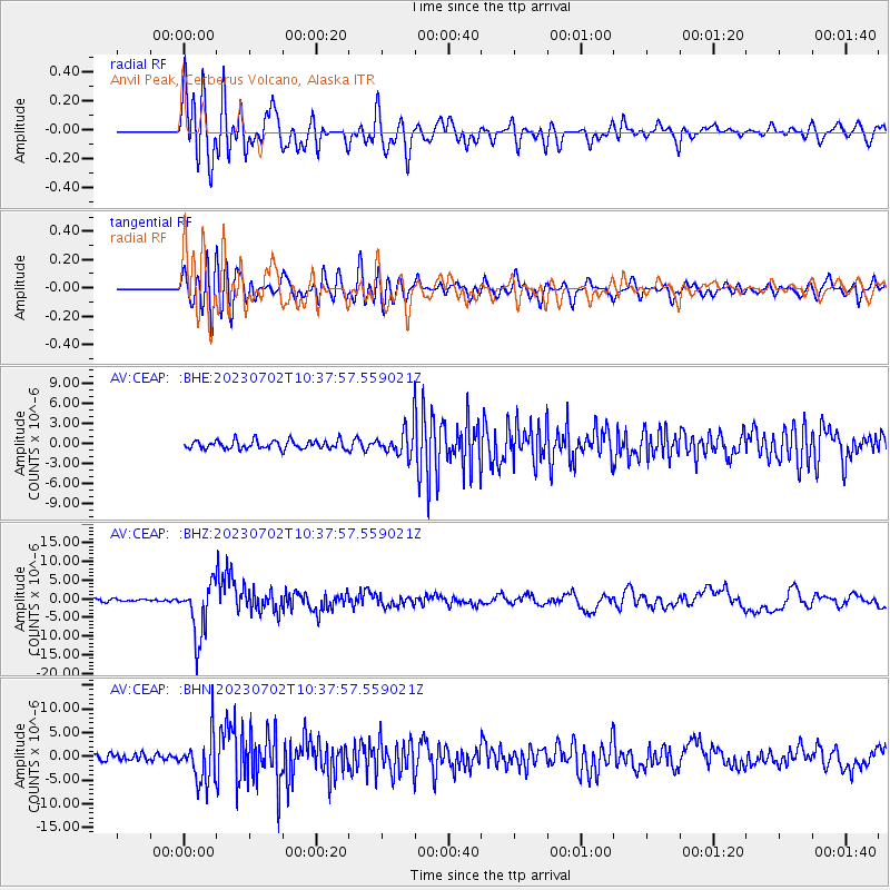
Signal To Noise
| Channel | StoN | STA | LTA |
| AV:CEAP: :BHZ:20230702T10:37:57.559021Z | 19.952513 | 7.275095E-6 | 3.646205E-7 |
| AV:CEAP: :BHN:20230702T10:37:57.559021Z | 8.068651 | 5.0535145E-6 | 6.2631466E-7 |
| AV:CEAP: :BHE:20230702T10:37:57.559021Z | 3.6467438 | 2.394448E-6 | 6.5659896E-7 |
| Arrivals |
| Ps | 3.0 SECOND |
| PpPs | 8.7 SECOND |
| PsPs/PpSs | 12 SECOND |


