You are here: Home > Network List > AV - Alaska Volcano Observatory Stations List
> Station GSTR Teapot Rock, Great Sitkin Volcano, Alaska > Earthquake Result Viewer
GSTR Teapot Rock, Great Sitkin Volcano, Alaska - Earthquake Result Viewer
| Earthquake location: |
Tonga Islands |
| Earthquake latitude/longitude: |
-17.9/-174.7 |
| Earthquake time(UTC): |
2023/07/02 (183) 10:27:45 GMT |
| Earthquake Depth: |
247 km |
| Earthquake Magnitude: |
6.7 Mi |
| Earthquake Catalog/Contributor: |
NEIC PDE/at |
|
| Network: |
AV Alaska Volcano Observatory |
| Station: |
GSTR Teapot Rock, Great Sitkin Volcano, Alaska |
| Lat/Lon: |
52.09 N/176.06 W |
| Elevation: |
536 m |
|
| Distance: |
69.7 deg |
| Az: |
359.105 deg |
| Baz: |
178.618 deg |
| Ray Param: |
0.05476092 |
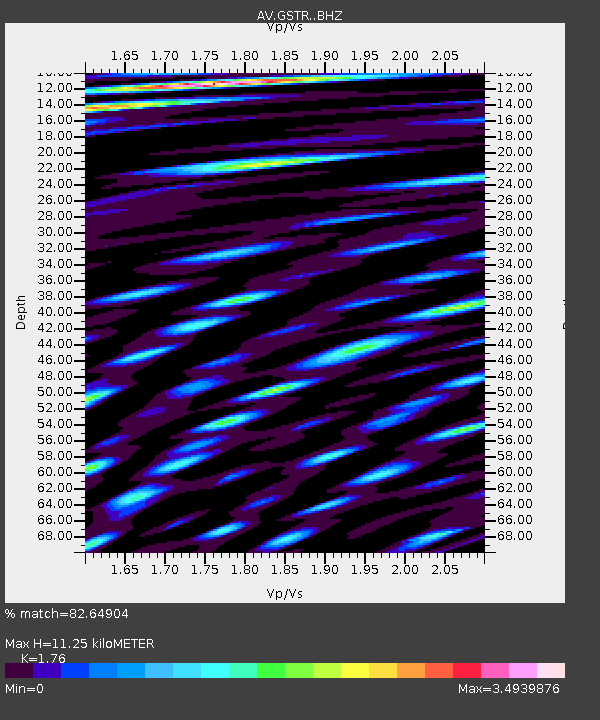
| Estimated Moho Depth: |
11.25 km |
| Estimated Crust Vp/Vs: |
1.76 |
| Assumed Crust Vp: |
3.912 km/s |
| Estimated Crust Vs: |
2.223 km/s |
| Estimated Crust Poisson's Ratio: |
0.26 |
|
| Radial Match: |
82.64904 % |
| Radial Bump: |
400 |
| Transverse Match: |
72.9654 % |
| Transverse Bump: |
400 |
| SOD ConfigId: |
30536071 |
| Insert Time: |
2023-07-16 10:37:23.421 +0000 |
| GWidth: |
2.5 |
| Max Bumps: |
400 |
| Tol: |
0.001 |
|

Signal To Noise
| Channel | StoN | STA | LTA |
| AV:GSTR: :BHZ:20230702T10:37:57.099976Z | 13.423793 | 9.125284E-6 | 6.7978436E-7 |
| AV:GSTR: :BHN:20230702T10:37:57.099976Z | 2.8347766 | 6.9805455E-6 | 2.4624676E-6 |
| AV:GSTR: :BHE:20230702T10:37:57.099976Z | 3.2647865 | 5.2964438E-6 | 1.622294E-6 |
| Arrivals |
| Ps | 2.2 SECOND |
| PpPs | 7.8 SECOND |
| PsPs/PpSs | 10 SECOND |


