You are here: Home > Network List > TA - USArray Transportable Network (new EarthScope stations) Stations List
> Station D22A Cohagen, MT, USA > Earthquake Result Viewer
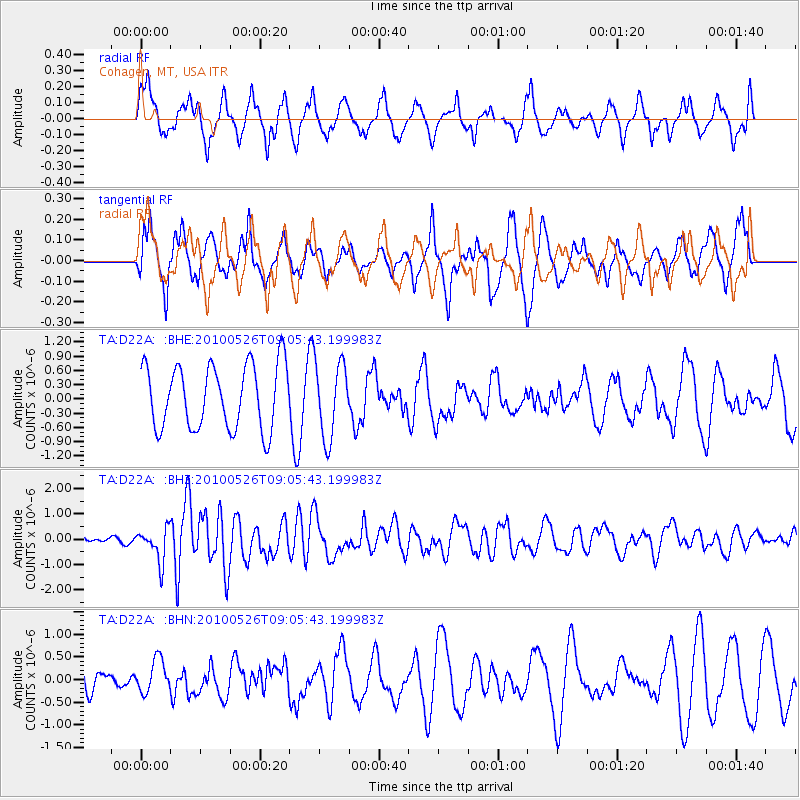
D22A Cohagen, MT, USA - Earthquake Result Viewer
*The percent match for this event was below the threshold and hence no stack was calculated.
| Earthquake location: |
Southeast Of Ryukyu Islands |
| Earthquake latitude/longitude: |
25.8/129.9 |
| Earthquake time(UTC): |
2010/05/26 (146) 08:53:08 GMT |
| Earthquake Depth: |
10 km |
| Earthquake Magnitude: |
6.2 MB, 6.2 MS, 6.5 MW, 6.5 MW |
| Earthquake Catalog/Contributor: |
WHDF/NEIC |
|
| Network: |
TA USArray Transportable Network (new EarthScope stations) |
| Station: |
D22A Cohagen, MT, USA |
| Lat/Lon: |
47.15 N/106.18 W |
| Elevation: |
791 m |
|
| Distance: |
91.5 deg |
| Az: |
34.533 deg |
| Baz: |
311.507 deg |
| Ray Param: |
$rayparam |
*The percent match for this event was below the threshold and hence was not used in the summary stack. |
|
| Radial Match: |
65.02265 % |
| Radial Bump: |
400 |
| Transverse Match: |
53.462894 % |
| Transverse Bump: |
400 |
| SOD ConfigId: |
314592 |
| Insert Time: |
2010-09-14 07:07:45.031 +0000 |
| GWidth: |
2.5 |
| Max Bumps: |
400 |
| Tol: |
0.001 |
|
Signal To Noise
| Channel | StoN | STA | LTA |
| TA:D22A: :BHZ:20100526T09:05:43.199983Z | 5.114261 | 6.574909E-7 | 1.2856029E-7 |
| TA:D22A: :BHN:20100526T09:05:43.199983Z | 0.80354065 | 3.5838994E-7 | 4.4601342E-7 |
| TA:D22A: :BHE:20100526T09:05:43.199983Z | 1.1747106 | 7.8955264E-7 | 6.7212517E-7 |
| Arrivals |
| Ps | |
| PpPs | |
| PsPs/PpSs | |


