You are here: Home > Network List > AV - Alaska Volcano Observatory Stations List
> Station KEL Katmai Kelez, Alaska > Earthquake Result Viewer
KEL Katmai Kelez, Alaska - Earthquake Result Viewer
| Earthquake location: |
Tonga Islands |
| Earthquake latitude/longitude: |
-17.9/-174.7 |
| Earthquake time(UTC): |
2023/07/02 (183) 10:27:45 GMT |
| Earthquake Depth: |
247 km |
| Earthquake Magnitude: |
6.7 Mi |
| Earthquake Catalog/Contributor: |
NEIC PDE/at |
|
| Network: |
AV Alaska Volcano Observatory |
| Station: |
KEL Katmai Kelez, Alaska |
| Lat/Lon: |
58.44 N/155.74 W |
| Elevation: |
975 m |
|
| Distance: |
77.7 deg |
| Az: |
10.073 deg |
| Baz: |
198.461 deg |
| Ray Param: |
0.049524378 |
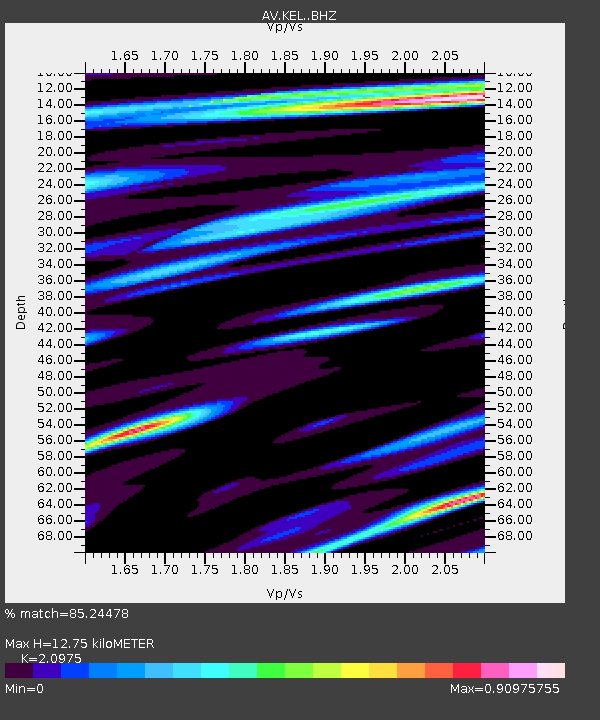
| Estimated Moho Depth: |
12.75 km |
| Estimated Crust Vp/Vs: |
2.10 |
| Assumed Crust Vp: |
6.438 km/s |
| Estimated Crust Vs: |
3.069 km/s |
| Estimated Crust Poisson's Ratio: |
0.35 |
|
| Radial Match: |
85.24478 % |
| Radial Bump: |
400 |
| Transverse Match: |
69.284996 % |
| Transverse Bump: |
400 |
| SOD ConfigId: |
30536071 |
| Insert Time: |
2023-07-16 10:37:49.893 +0000 |
| GWidth: |
2.5 |
| Max Bumps: |
400 |
| Tol: |
0.001 |
|

Signal To Noise
| Channel | StoN | STA | LTA |
| AV:KEL: :BHZ:20230702T10:38:43.059998Z | 12.671073 | 5.014654E-6 | 3.957561E-7 |
| AV:KEL: :BHN:20230702T10:38:43.059998Z | 3.4523482 | 2.0439072E-6 | 5.9203387E-7 |
| AV:KEL: :BHE:20230702T10:38:43.059998Z | 3.72403 | 1.0601099E-6 | 2.8466735E-7 |
| Arrivals |
| Ps | 2.2 SECOND |
| PpPs | 6.0 SECOND |
| PsPs/PpSs | 8.2 SECOND |


