You are here: Home > Network List > AV - Alaska Volcano Observatory Stations List
> Station SPCL Chakachamna Lake, Mount Spurr, Alaska > Earthquake Result Viewer
SPCL Chakachamna Lake, Mount Spurr, Alaska - Earthquake Result Viewer
| Earthquake location: |
Tonga Islands |
| Earthquake latitude/longitude: |
-17.9/-174.7 |
| Earthquake time(UTC): |
2023/07/02 (183) 10:27:45 GMT |
| Earthquake Depth: |
247 km |
| Earthquake Magnitude: |
6.7 Mi |
| Earthquake Catalog/Contributor: |
NEIC PDE/at |
|
| Network: |
AV Alaska Volcano Observatory |
| Station: |
SPCL Chakachamna Lake, Mount Spurr, Alaska |
| Lat/Lon: |
61.20 N/152.34 W |
| Elevation: |
1274 m |
|
| Distance: |
80.8 deg |
| Az: |
10.756 deg |
| Baz: |
201.526 deg |
| Ray Param: |
0.047373615 |
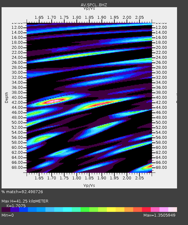
| Estimated Moho Depth: |
41.25 km |
| Estimated Crust Vp/Vs: |
1.71 |
| Assumed Crust Vp: |
6.566 km/s |
| Estimated Crust Vs: |
3.845 km/s |
| Estimated Crust Poisson's Ratio: |
0.24 |
|
| Radial Match: |
92.498726 % |
| Radial Bump: |
400 |
| Transverse Match: |
90.33099 % |
| Transverse Bump: |
400 |
| SOD ConfigId: |
30536071 |
| Insert Time: |
2023-07-16 10:39:16.589 +0000 |
| GWidth: |
2.5 |
| Max Bumps: |
400 |
| Tol: |
0.001 |
|

Signal To Noise
| Channel | StoN | STA | LTA |
| AV:SPCL: :BHZ:20230702T10:39:00.159973Z | 42.252167 | 4.3138843E-6 | 1.0209855E-7 |
| AV:SPCL: :BHN:20230702T10:39:00.159973Z | 19.12017 | 1.9603485E-6 | 1.0252778E-7 |
| AV:SPCL: :BHE:20230702T10:39:00.159973Z | 11.260533 | 1.0595751E-6 | 9.409635E-8 |
| Arrivals |
| Ps | 4.6 SECOND |
| PpPs | 17 SECOND |
| PsPs/PpSs | 21 SECOND |


