You are here: Home > Network List > TA - USArray Transportable Network (new EarthScope stations) Stations List
> Station M25A Palm-Egli Farm, Albin, WY, USA > Earthquake Result Viewer
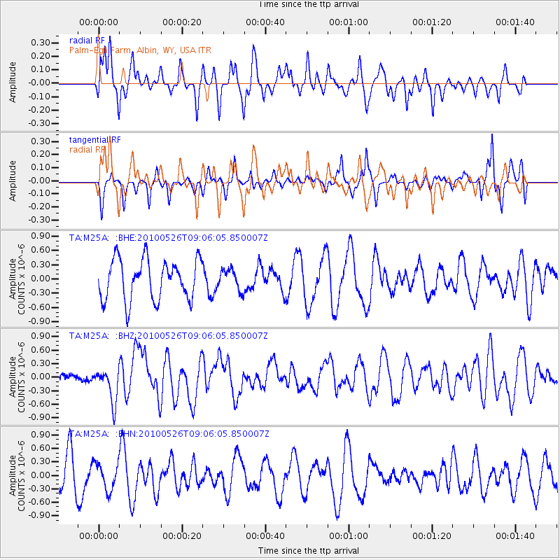
M25A Palm-Egli Farm, Albin, WY, USA - Earthquake Result Viewer
*The percent match for this event was below the threshold and hence no stack was calculated.
| Earthquake location: |
Southeast Of Ryukyu Islands |
| Earthquake latitude/longitude: |
25.8/129.9 |
| Earthquake time(UTC): |
2010/05/26 (146) 08:53:08 GMT |
| Earthquake Depth: |
10 km |
| Earthquake Magnitude: |
6.2 MB, 6.2 MS, 6.5 MW, 6.5 MW |
| Earthquake Catalog/Contributor: |
WHDF/NEIC |
|
| Network: |
TA USArray Transportable Network (new EarthScope stations) |
| Station: |
M25A Palm-Egli Farm, Albin, WY, USA |
| Lat/Lon: |
41.43 N/104.06 W |
| Elevation: |
1636 m |
|
| Distance: |
96.5 deg |
| Az: |
37.753 deg |
| Baz: |
312.761 deg |
| Ray Param: |
$rayparam |
*The percent match for this event was below the threshold and hence was not used in the summary stack. |
|
| Radial Match: |
41.958073 % |
| Radial Bump: |
394 |
| Transverse Match: |
45.262352 % |
| Transverse Bump: |
252 |
| SOD ConfigId: |
314592 |
| Insert Time: |
2010-09-14 07:09:19.729 +0000 |
| GWidth: |
2.5 |
| Max Bumps: |
400 |
| Tol: |
0.001 |
|
Signal To Noise
| Channel | StoN | STA | LTA |
| TA:M25A: :BHZ:20100526T09:06:05.850007Z | 2.9041479 | 3.9263114E-7 | 1.3519667E-7 |
| TA:M25A: :BHN:20100526T09:06:05.850007Z | 0.99545515 | 2.9628313E-7 | 2.9763584E-7 |
| TA:M25A: :BHE:20100526T09:06:05.850007Z | 0.52802056 | 2.2416619E-7 | 4.2454064E-7 |
| Arrivals |
| Ps | |
| PpPs | |
| PsPs/PpSs | |


