You are here: Home > Network List > TA - USArray Transportable Network (new EarthScope stations) Stations List
> Station G22A Birney, MT, USA > Earthquake Result Viewer
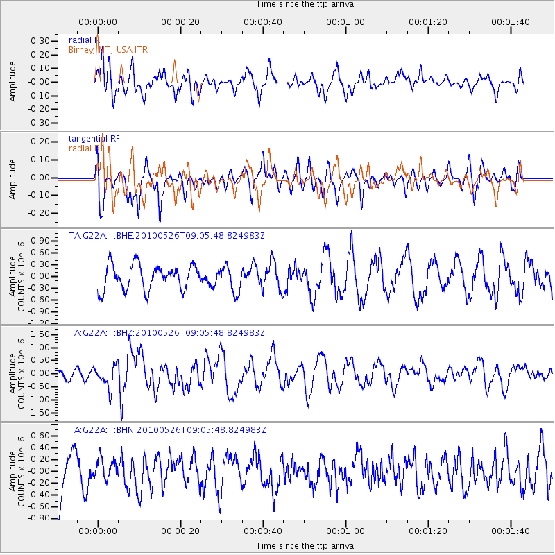
G22A Birney, MT, USA - Earthquake Result Viewer
*The percent match for this event was below the threshold and hence no stack was calculated.
| Earthquake location: |
Southeast Of Ryukyu Islands |
| Earthquake latitude/longitude: |
25.8/129.9 |
| Earthquake time(UTC): |
2010/05/26 (146) 08:53:08 GMT |
| Earthquake Depth: |
10 km |
| Earthquake Magnitude: |
6.2 MB, 6.2 MS, 6.5 MW, 6.5 MW |
| Earthquake Catalog/Contributor: |
WHDF/NEIC |
|
| Network: |
TA USArray Transportable Network (new EarthScope stations) |
| Station: |
G22A Birney, MT, USA |
| Lat/Lon: |
45.22 N/106.29 W |
| Elevation: |
1203 m |
|
| Distance: |
92.8 deg |
| Az: |
36.033 deg |
| Baz: |
311.37 deg |
| Ray Param: |
$rayparam |
*The percent match for this event was below the threshold and hence was not used in the summary stack. |
|
| Radial Match: |
67.62959 % |
| Radial Bump: |
400 |
| Transverse Match: |
58.886368 % |
| Transverse Bump: |
400 |
| SOD ConfigId: |
314592 |
| Insert Time: |
2010-09-14 07:09:44.066 +0000 |
| GWidth: |
2.5 |
| Max Bumps: |
400 |
| Tol: |
0.001 |
|
Signal To Noise
| Channel | StoN | STA | LTA |
| TA:G22A: :BHZ:20100526T09:05:48.824983Z | 2.6756887 | 4.3848178E-7 | 1.6387624E-7 |
| TA:G22A: :BHN:20100526T09:05:48.824983Z | 0.59399897 | 1.7758562E-7 | 2.989662E-7 |
| TA:G22A: :BHE:20100526T09:05:48.824983Z | 1.041222 | 3.2965295E-7 | 3.16602E-7 |
| Arrivals |
| Ps | |
| PpPs | |
| PsPs/PpSs | |


