You are here: Home > Network List > C8 - Canadian Seismic Research Network () Stations List
> Station GRIB Gribbell Island, BC, CA > Earthquake Result Viewer
GRIB Gribbell Island, BC, CA - Earthquake Result Viewer
| Earthquake location: |
Tonga Islands |
| Earthquake latitude/longitude: |
-17.9/-174.7 |
| Earthquake time(UTC): |
2023/07/02 (183) 10:27:45 GMT |
| Earthquake Depth: |
247 km |
| Earthquake Magnitude: |
6.7 Mi |
| Earthquake Catalog/Contributor: |
NEIC PDE/at |
|
| Network: |
C8 Canadian Seismic Research Network () |
| Station: |
GRIB Gribbell Island, BC, CA |
| Lat/Lon: |
53.34 N/129.14 W |
| Elevation: |
418 m |
|
| Distance: |
81.1 deg |
| Az: |
25.685 deg |
| Baz: |
223.49 deg |
| Ray Param: |
0.047214117 |
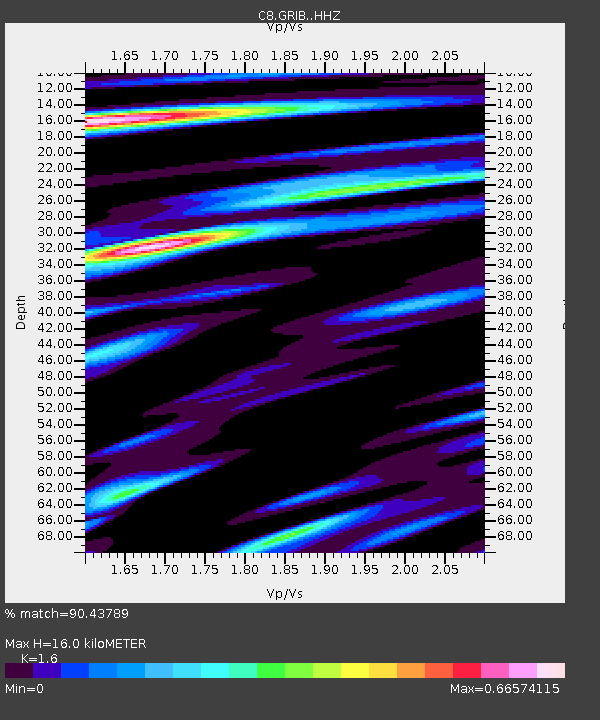
| Estimated Moho Depth: |
16.0 km |
| Estimated Crust Vp/Vs: |
1.60 |
| Assumed Crust Vp: |
6.545 km/s |
| Estimated Crust Vs: |
4.091 km/s |
| Estimated Crust Poisson's Ratio: |
0.18 |
|
| Radial Match: |
90.43789 % |
| Radial Bump: |
400 |
| Transverse Match: |
90.39489 % |
| Transverse Bump: |
400 |
| SOD ConfigId: |
30536071 |
| Insert Time: |
2023-07-16 10:41:48.908 +0000 |
| GWidth: |
2.5 |
| Max Bumps: |
400 |
| Tol: |
0.001 |
|
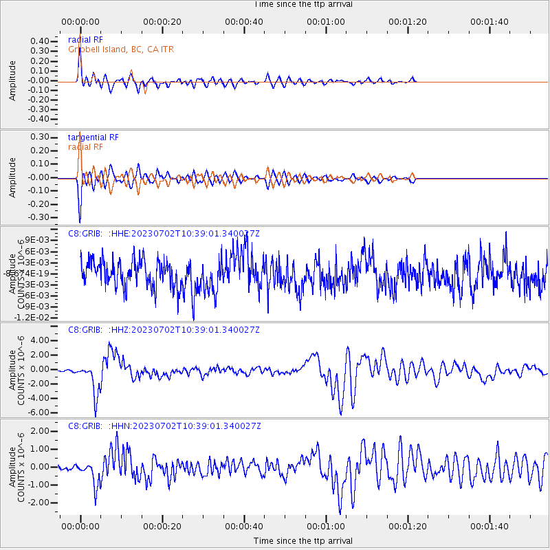
Signal To Noise
| Channel | StoN | STA | LTA |
| C8:GRIB: :HHZ:20230702T10:39:01.340027Z | 15.555507 | 2.213878E-6 | 1.4232117E-7 |
| C8:GRIB: :HHN:20230702T10:39:01.340027Z | 6.208222 | 6.7317427E-7 | 1.08432694E-7 |
| C8:GRIB: :HHE:20230702T10:39:01.340027Z | 1.2639077 | 4.391426E-9 | 3.4744831E-9 |
| Arrivals |
| Ps | 1.5 SECOND |
| PpPs | 6.2 SECOND |
| PsPs/PpSs | 7.7 SECOND |


