You are here: Home > Network List > CC - Cascade Chain Volcano Monitoring Stations List
> Station HUSB The Husband > Earthquake Result Viewer
HUSB The Husband - Earthquake Result Viewer
| Earthquake location: |
Tonga Islands |
| Earthquake latitude/longitude: |
-17.9/-174.7 |
| Earthquake time(UTC): |
2023/07/02 (183) 10:27:45 GMT |
| Earthquake Depth: |
247 km |
| Earthquake Magnitude: |
6.7 Mi |
| Earthquake Catalog/Contributor: |
NEIC PDE/at |
|
| Network: |
CC Cascade Chain Volcano Monitoring |
| Station: |
HUSB The Husband |
| Lat/Lon: |
44.12 N/121.85 W |
| Elevation: |
2038 m |
|
| Distance: |
78.3 deg |
| Az: |
35.886 deg |
| Baz: |
230.802 deg |
| Ray Param: |
0.049074095 |
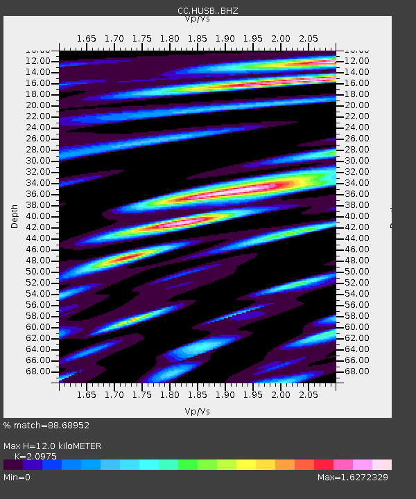
| Estimated Moho Depth: |
12.0 km |
| Estimated Crust Vp/Vs: |
2.10 |
| Assumed Crust Vp: |
6.597 km/s |
| Estimated Crust Vs: |
3.145 km/s |
| Estimated Crust Poisson's Ratio: |
0.35 |
|
| Radial Match: |
88.68952 % |
| Radial Bump: |
400 |
| Transverse Match: |
85.177376 % |
| Transverse Bump: |
400 |
| SOD ConfigId: |
30536071 |
| Insert Time: |
2023-07-16 10:42:23.177 +0000 |
| GWidth: |
2.5 |
| Max Bumps: |
400 |
| Tol: |
0.001 |
|

Signal To Noise
| Channel | StoN | STA | LTA |
| CC:HUSB: :BHZ:20230702T10:38:46.76001Z | 9.772547 | 1.9247311E-6 | 1.9695287E-7 |
| CC:HUSB: :BHN:20230702T10:38:46.76001Z | 0.68298286 | 1.5521275E-7 | 2.2725716E-7 |
| CC:HUSB: :BHE:20230702T10:38:46.76001Z | 1.5893959 | 5.1607304E-7 | 3.246976E-7 |
| Arrivals |
| Ps | 2.0 SECOND |
| PpPs | 5.5 SECOND |
| PsPs/PpSs | 7.5 SECOND |


