You are here: Home > Network List > CC - Cascade Chain Volcano Monitoring Stations List
> Station LSON Lamberson Butte > Earthquake Result Viewer
LSON Lamberson Butte - Earthquake Result Viewer
| Earthquake location: |
Tonga Islands |
| Earthquake latitude/longitude: |
-17.9/-174.7 |
| Earthquake time(UTC): |
2023/07/02 (183) 10:27:45 GMT |
| Earthquake Depth: |
247 km |
| Earthquake Magnitude: |
6.7 Mi |
| Earthquake Catalog/Contributor: |
NEIC PDE/at |
|
| Network: |
CC Cascade Chain Volcano Monitoring |
| Station: |
LSON Lamberson Butte |
| Lat/Lon: |
45.36 N/121.65 W |
| Elevation: |
1881 m |
|
| Distance: |
79.2 deg |
| Az: |
34.999 deg |
| Baz: |
230.772 deg |
| Ray Param: |
0.04847074 |
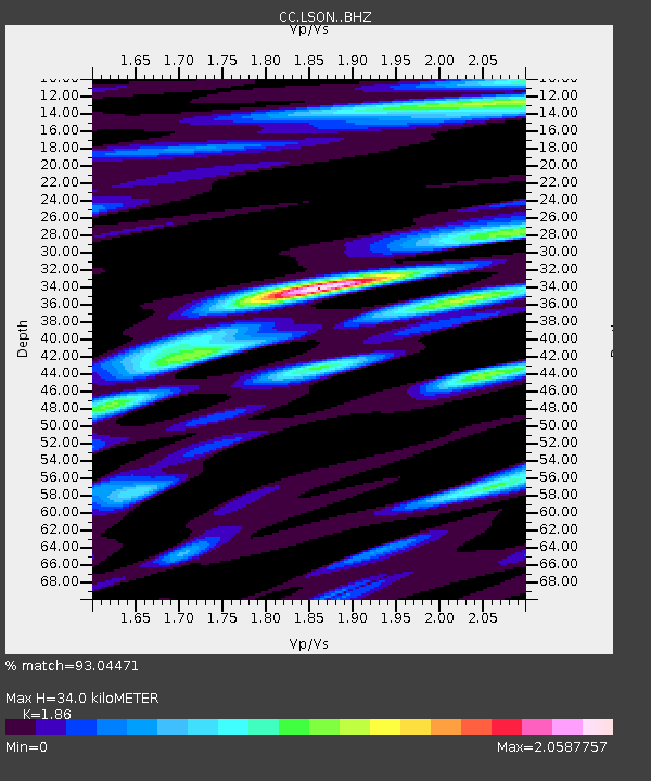
| Estimated Moho Depth: |
34.0 km |
| Estimated Crust Vp/Vs: |
1.86 |
| Assumed Crust Vp: |
6.597 km/s |
| Estimated Crust Vs: |
3.547 km/s |
| Estimated Crust Poisson's Ratio: |
0.30 |
|
| Radial Match: |
93.04471 % |
| Radial Bump: |
400 |
| Transverse Match: |
88.20058 % |
| Transverse Bump: |
400 |
| SOD ConfigId: |
30536071 |
| Insert Time: |
2023-07-16 10:42:30.247 +0000 |
| GWidth: |
2.5 |
| Max Bumps: |
400 |
| Tol: |
0.001 |
|

Signal To Noise
| Channel | StoN | STA | LTA |
| CC:LSON: :BHZ:20230702T10:38:51.599976Z | 16.702053 | 1.9252905E-6 | 1.15272684E-7 |
| CC:LSON: :BHN:20230702T10:38:51.599976Z | 3.7627342 | 8.677593E-7 | 2.3061935E-7 |
| CC:LSON: :BHE:20230702T10:38:51.599976Z | 1.6089491 | 2.918199E-7 | 1.81373E-7 |
| Arrivals |
| Ps | 4.6 SECOND |
| PpPs | 14 SECOND |
| PsPs/PpSs | 19 SECOND |


