You are here: Home > Network List > CC - Cascade Chain Volcano Monitoring Stations List
> Station PALM Top of Palmer Lift > Earthquake Result Viewer
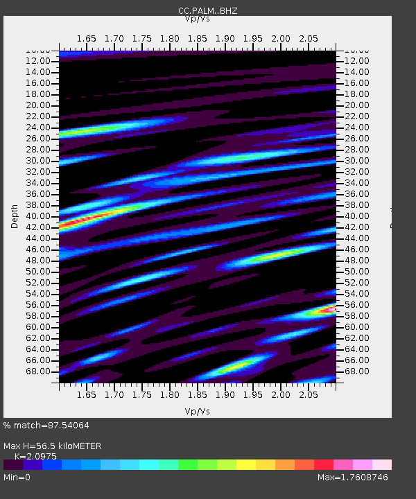
PALM Top of Palmer Lift - Earthquake Result Viewer
| Earthquake location: |
Tonga Islands |
| Earthquake latitude/longitude: |
-17.9/-174.7 |
| Earthquake time(UTC): |
2023/07/02 (183) 10:27:45 GMT |
| Earthquake Depth: |
247 km |
| Earthquake Magnitude: |
6.7 Mi |
| Earthquake Catalog/Contributor: |
NEIC PDE/at |
|
| Network: |
CC Cascade Chain Volcano Monitoring |
| Station: |
PALM Top of Palmer Lift |
| Lat/Lon: |
45.36 N/121.71 W |
| Elevation: |
2590 m |
|
| Distance: |
79.2 deg |
| Az: |
34.974 deg |
| Baz: |
230.725 deg |
| Ray Param: |
0.04849287 |
| Estimated Moho Depth: |
56.5 km |
| Estimated Crust Vp/Vs: |
2.10 |
| Assumed Crust Vp: |
6.597 km/s |
| Estimated Crust Vs: |
3.145 km/s |
| Estimated Crust Poisson's Ratio: |
0.35 |
|
| Radial Match: |
87.54064 % |
| Radial Bump: |
400 |
| Transverse Match: |
92.696465 % |
| Transverse Bump: |
400 |
| SOD ConfigId: |
30536071 |
| Insert Time: |
2023-07-16 10:42:41.134 +0000 |
| GWidth: |
2.5 |
| Max Bumps: |
400 |
| Tol: |
0.001 |
|

Signal To Noise
| Channel | StoN | STA | LTA |
| CC:PALM: :BHZ:20230702T10:38:51.440002Z | 9.422134 | 1.9767122E-6 | 2.097945E-7 |
| CC:PALM: :BHN:20230702T10:38:51.440002Z | 5.5389247 | 1.2339017E-6 | 2.2276919E-7 |
| CC:PALM: :BHE:20230702T10:38:51.440002Z | 1.8010963 | 4.258127E-7 | 2.364186E-7 |
| Arrivals |
| Ps | 9.6 SECOND |
| PpPs | 26 SECOND |
| PsPs/PpSs | 36 SECOND |


