You are here: Home > Network List > TA - USArray Transportable Network (new EarthScope stations) Stations List
> Station H28A Mission Ridge, SD, USA > Earthquake Result Viewer
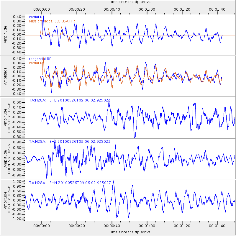
H28A Mission Ridge, SD, USA - Earthquake Result Viewer
*The percent match for this event was below the threshold and hence no stack was calculated.
| Earthquake location: |
Southeast Of Ryukyu Islands |
| Earthquake latitude/longitude: |
25.8/129.9 |
| Earthquake time(UTC): |
2010/05/26 (146) 08:53:08 GMT |
| Earthquake Depth: |
10 km |
| Earthquake Magnitude: |
6.2 MB, 6.2 MS, 6.5 MW, 6.5 MW |
| Earthquake Catalog/Contributor: |
WHDF/NEIC |
|
| Network: |
TA USArray Transportable Network (new EarthScope stations) |
| Station: |
H28A Mission Ridge, SD, USA |
| Lat/Lon: |
44.68 N/101.02 W |
| Elevation: |
642 m |
|
| Distance: |
95.9 deg |
| Az: |
33.856 deg |
| Baz: |
315.247 deg |
| Ray Param: |
$rayparam |
*The percent match for this event was below the threshold and hence was not used in the summary stack. |
|
| Radial Match: |
54.818596 % |
| Radial Bump: |
395 |
| Transverse Match: |
61.244934 % |
| Transverse Bump: |
377 |
| SOD ConfigId: |
314592 |
| Insert Time: |
2010-09-14 07:10:25.836 +0000 |
| GWidth: |
2.5 |
| Max Bumps: |
400 |
| Tol: |
0.001 |
|
Signal To Noise
| Channel | StoN | STA | LTA |
| TA:H28A: :BHZ:20100526T09:06:02.92502Z | 3.6342947 | 3.6523917E-7 | 1.0049794E-7 |
| TA:H28A: :BHN:20100526T09:06:02.92502Z | 0.8286979 | 2.854512E-7 | 3.4445748E-7 |
| TA:H28A: :BHE:20100526T09:06:02.92502Z | 0.527135 | 8.311801E-8 | 1.576788E-7 |
| Arrivals |
| Ps | |
| PpPs | |
| PsPs/PpSs | |


