You are here: Home > Network List > CC - Cascade Chain Volcano Monitoring Stations List
> Station TAVI Tahoma Vista > Earthquake Result Viewer
TAVI Tahoma Vista - Earthquake Result Viewer
| Earthquake location: |
Tonga Islands |
| Earthquake latitude/longitude: |
-17.9/-174.7 |
| Earthquake time(UTC): |
2023/07/02 (183) 10:27:45 GMT |
| Earthquake Depth: |
247 km |
| Earthquake Magnitude: |
6.7 Mi |
| Earthquake Catalog/Contributor: |
NEIC PDE/at |
|
| Network: |
CC Cascade Chain Volcano Monitoring |
| Station: |
TAVI Tahoma Vista |
| Lat/Lon: |
46.80 N/121.88 W |
| Elevation: |
1055 m |
|
| Distance: |
80.0 deg |
| Az: |
33.765 deg |
| Baz: |
230.379 deg |
| Ray Param: |
0.04793909 |
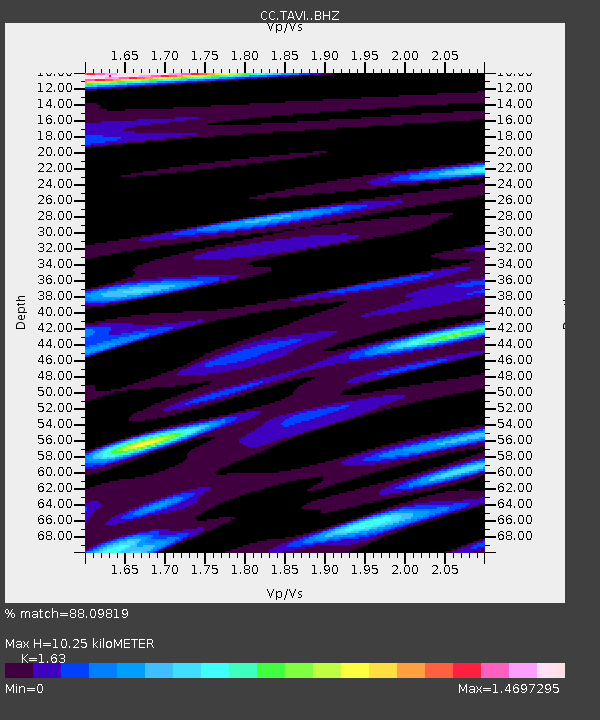
| Estimated Moho Depth: |
10.25 km |
| Estimated Crust Vp/Vs: |
1.63 |
| Assumed Crust Vp: |
6.597 km/s |
| Estimated Crust Vs: |
4.048 km/s |
| Estimated Crust Poisson's Ratio: |
0.20 |
|
| Radial Match: |
88.09819 % |
| Radial Bump: |
400 |
| Transverse Match: |
69.337494 % |
| Transverse Bump: |
400 |
| SOD ConfigId: |
30536071 |
| Insert Time: |
2023-07-16 10:43:16.825 +0000 |
| GWidth: |
2.5 |
| Max Bumps: |
400 |
| Tol: |
0.001 |
|

Signal To Noise
| Channel | StoN | STA | LTA |
| CC:TAVI: :BHZ:20230702T10:38:55.799988Z | 14.775047 | 1.5477375E-6 | 1.0475347E-7 |
| CC:TAVI: :BHN:20230702T10:38:55.799988Z | 5.5558267 | 5.604971E-7 | 1.0088455E-7 |
| CC:TAVI: :BHE:20230702T10:38:55.799988Z | 3.6960418 | 3.4945288E-7 | 9.454787E-8 |
| Arrivals |
| Ps | 1.0 SECOND |
| PpPs | 4.0 SECOND |
| PsPs/PpSs | 5.0 SECOND |


