You are here: Home > Network List > CI - Caltech Regional Seismic Network Stations List
> Station BEL Belle Mtn, Joshua Tree National Park, CA, USA > Earthquake Result Viewer
BEL Belle Mtn, Joshua Tree National Park, CA, USA - Earthquake Result Viewer
| Earthquake location: |
Tonga Islands |
| Earthquake latitude/longitude: |
-17.9/-174.7 |
| Earthquake time(UTC): |
2023/07/02 (183) 10:27:45 GMT |
| Earthquake Depth: |
247 km |
| Earthquake Magnitude: |
6.7 Mi |
| Earthquake Catalog/Contributor: |
NEIC PDE/at |
|
| Network: |
CI Caltech Regional Seismic Network |
| Station: |
BEL Belle Mtn, Joshua Tree National Park, CA, USA |
| Lat/Lon: |
34.00 N/116.00 W |
| Elevation: |
1388 m |
|
| Distance: |
76.1 deg |
| Az: |
47.005 deg |
| Baz: |
236.963 deg |
| Ray Param: |
0.05058969 |
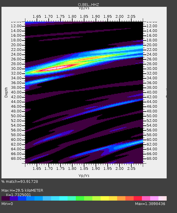
| Estimated Moho Depth: |
29.5 km |
| Estimated Crust Vp/Vs: |
1.73 |
| Assumed Crust Vp: |
6.276 km/s |
| Estimated Crust Vs: |
3.622 km/s |
| Estimated Crust Poisson's Ratio: |
0.25 |
|
| Radial Match: |
93.91728 % |
| Radial Bump: |
337 |
| Transverse Match: |
81.92776 % |
| Transverse Bump: |
400 |
| SOD ConfigId: |
30536071 |
| Insert Time: |
2023-07-16 10:43:42.408 +0000 |
| GWidth: |
2.5 |
| Max Bumps: |
400 |
| Tol: |
0.001 |
|
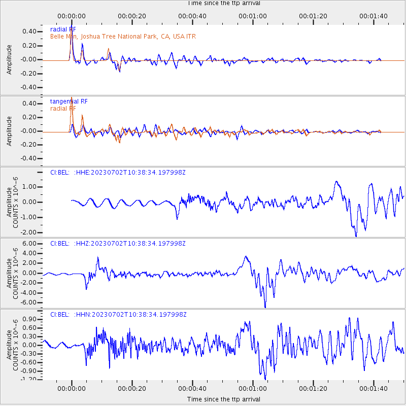
Signal To Noise
| Channel | StoN | STA | LTA |
| CI:BEL: :HHZ:20230702T10:38:34.197998Z | 4.386766 | 6.37847E-7 | 1.4540255E-7 |
| CI:BEL: :HHN:20230702T10:38:34.197998Z | 1.1869122 | 1.4139245E-7 | 1.1912629E-7 |
| CI:BEL: :HHE:20230702T10:38:34.197998Z | 1.2258166 | 2.1701247E-7 | 1.7703502E-7 |
| Arrivals |
| Ps | 3.5 SECOND |
| PpPs | 12 SECOND |
| PsPs/PpSs | 16 SECOND |


