You are here: Home > Network List > GM - US Geological Survey Networks Stations List
> Station IWM01 Jericho 2M Well Monitoring Station > Earthquake Result Viewer
IWM01 Jericho 2M Well Monitoring Station - Earthquake Result Viewer
| Earthquake location: |
Tonga Islands |
| Earthquake latitude/longitude: |
-17.9/-174.7 |
| Earthquake time(UTC): |
2023/07/02 (183) 10:27:45 GMT |
| Earthquake Depth: |
247 km |
| Earthquake Magnitude: |
6.7 Mi |
| Earthquake Catalog/Contributor: |
NEIC PDE/at |
|
| Network: |
GM US Geological Survey Networks |
| Station: |
IWM01 Jericho 2M Well Monitoring Station |
| Lat/Lon: |
36.73 N/96.53 W |
| Elevation: |
328 m |
|
| Distance: |
91.4 deg |
| Az: |
51.868 deg |
| Baz: |
248.789 deg |
| Ray Param: |
0.041495427 |
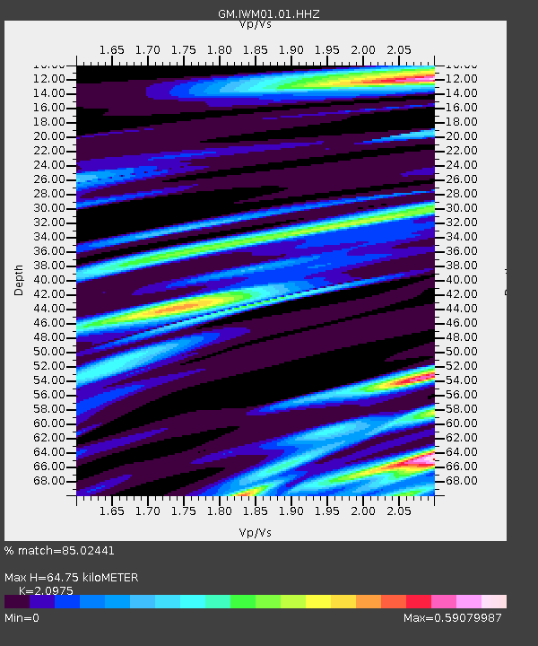
| Estimated Moho Depth: |
64.75 km |
| Estimated Crust Vp/Vs: |
2.10 |
| Assumed Crust Vp: |
6.483 km/s |
| Estimated Crust Vs: |
3.091 km/s |
| Estimated Crust Poisson's Ratio: |
0.35 |
|
| Radial Match: |
85.02441 % |
| Radial Bump: |
400 |
| Transverse Match: |
35.920258 % |
| Transverse Bump: |
400 |
| SOD ConfigId: |
30536071 |
| Insert Time: |
2023-07-16 10:48:22.668 +0000 |
| GWidth: |
2.5 |
| Max Bumps: |
400 |
| Tol: |
0.001 |
|
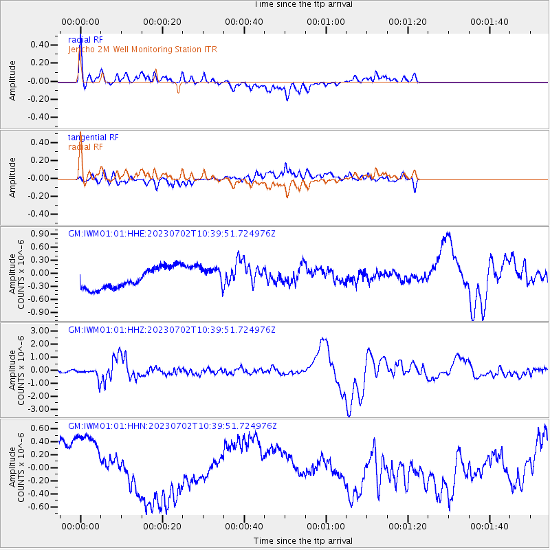
Signal To Noise
| Channel | StoN | STA | LTA |
| GM:IWM01:01:HHZ:20230702T10:39:51.724976Z | 4.4920964 | 4.1170514E-7 | 9.1651E-8 |
| GM:IWM01:01:HHN:20230702T10:39:51.724976Z | 2.2914944 | 5.171633E-7 | 2.2568823E-7 |
| GM:IWM01:01:HHE:20230702T10:39:51.724976Z | 0.9582999 | 2.2483317E-7 | 2.3461672E-7 |
| Arrivals |
| Ps | 11 SECOND |
| PpPs | 30 SECOND |
| PsPs/PpSs | 42 SECOND |


