You are here: Home > Network List > GS - US Geological Survey Networks Stations List
> Station MCA04 MCA04, Monte Cristo Range, NV > Earthquake Result Viewer
MCA04 MCA04, Monte Cristo Range, NV - Earthquake Result Viewer
| Earthquake location: |
Tonga Islands |
| Earthquake latitude/longitude: |
-17.9/-174.7 |
| Earthquake time(UTC): |
2023/07/02 (183) 10:27:45 GMT |
| Earthquake Depth: |
247 km |
| Earthquake Magnitude: |
6.7 Mi |
| Earthquake Catalog/Contributor: |
NEIC PDE/at |
|
| Network: |
GS US Geological Survey Networks |
| Station: |
MCA04 MCA04, Monte Cristo Range, NV |
| Lat/Lon: |
38.08 N/117.71 W |
| Elevation: |
1662 m |
|
| Distance: |
77.2 deg |
| Az: |
42.743 deg |
| Baz: |
234.974 deg |
| Ray Param: |
0.04984438 |
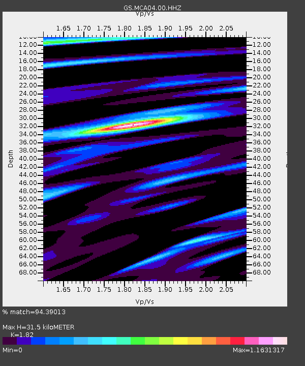
| Estimated Moho Depth: |
31.5 km |
| Estimated Crust Vp/Vs: |
1.82 |
| Assumed Crust Vp: |
6.276 km/s |
| Estimated Crust Vs: |
3.448 km/s |
| Estimated Crust Poisson's Ratio: |
0.28 |
|
| Radial Match: |
94.39013 % |
| Radial Bump: |
386 |
| Transverse Match: |
96.442955 % |
| Transverse Bump: |
321 |
| SOD ConfigId: |
30536071 |
| Insert Time: |
2023-07-16 10:48:39.202 +0000 |
| GWidth: |
2.5 |
| Max Bumps: |
400 |
| Tol: |
0.001 |
|

Signal To Noise
| Channel | StoN | STA | LTA |
| GS:MCA04:00:HHZ:20230702T10:38:40.47998Z | 15.97117 | 1.2941713E-6 | 8.1031715E-8 |
| GS:MCA04:00:HH1:20230702T10:38:40.47998Z | 2.075013 | 1.8087727E-7 | 8.716922E-8 |
| GS:MCA04:00:HH2:20230702T10:38:40.47998Z | 1.9310007 | 2.1701467E-7 | 1.1238456E-7 |
| Arrivals |
| Ps | 4.2 SECOND |
| PpPs | 14 SECOND |
| PsPs/PpSs | 18 SECOND |


