You are here: Home > Network List > GS - US Geological Survey Networks Stations List
> Station OK051 E0350 and S34600 roads, Ralston OK > Earthquake Result Viewer
OK051 E0350 and S34600 roads, Ralston OK - Earthquake Result Viewer
| Earthquake location: |
Tonga Islands |
| Earthquake latitude/longitude: |
-17.9/-174.7 |
| Earthquake time(UTC): |
2023/07/02 (183) 10:27:45 GMT |
| Earthquake Depth: |
247 km |
| Earthquake Magnitude: |
6.7 Mi |
| Earthquake Catalog/Contributor: |
NEIC PDE/at |
|
| Network: |
GS US Geological Survey Networks |
| Station: |
OK051 E0350 and S34600 roads, Ralston OK |
| Lat/Lon: |
36.50 N/96.84 W |
| Elevation: |
263 m |
|
| Distance: |
91.1 deg |
| Az: |
51.986 deg |
| Baz: |
248.606 deg |
| Ray Param: |
0.04154316 |
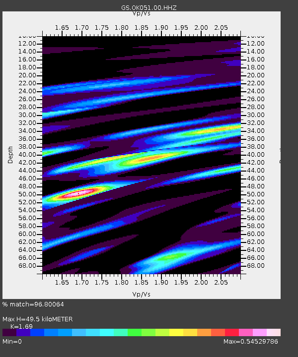
| Estimated Moho Depth: |
49.5 km |
| Estimated Crust Vp/Vs: |
1.69 |
| Assumed Crust Vp: |
6.483 km/s |
| Estimated Crust Vs: |
3.836 km/s |
| Estimated Crust Poisson's Ratio: |
0.23 |
|
| Radial Match: |
96.80064 % |
| Radial Bump: |
337 |
| Transverse Match: |
78.31692 % |
| Transverse Bump: |
400 |
| SOD ConfigId: |
30536071 |
| Insert Time: |
2023-07-16 10:48:41.779 +0000 |
| GWidth: |
2.5 |
| Max Bumps: |
400 |
| Tol: |
0.001 |
|

Signal To Noise
| Channel | StoN | STA | LTA |
| GS:OK051:00:HHZ:20230702T10:39:50.309021Z | 5.516071 | 3.3529577E-7 | 6.078525E-8 |
| GS:OK051:00:HH1:20230702T10:39:50.309021Z | 1.46839 | 7.8850654E-8 | 5.3698713E-8 |
| GS:OK051:00:HH2:20230702T10:39:50.309021Z | 1.5727828 | 7.591428E-8 | 4.8267495E-8 |
| Arrivals |
| Ps | 5.4 SECOND |
| PpPs | 20 SECOND |
| PsPs/PpSs | 25 SECOND |


