You are here: Home > Network List > IW - Intermountain West Stations List
> Station DLMT Dillon, Montana, USA > Earthquake Result Viewer
DLMT Dillon, Montana, USA - Earthquake Result Viewer

| Earthquake location: |
Tonga Islands |
| Earthquake latitude/longitude: |
-17.9/-174.7 |
| Earthquake time(UTC): |
2023/07/02 (183) 10:27:45 GMT |
| Earthquake Depth: |
247 km |
| Earthquake Magnitude: |
6.7 Mi |
| Earthquake Catalog/Contributor: |
NEIC PDE/at |
|
| Network: |
IW Intermountain West |
| Station: |
DLMT Dillon, Montana, USA |
| Lat/Lon: |
45.36 N/112.60 W |
| Elevation: |
1569 m |
|
| Distance: |
84.4 deg |
| Az: |
38.76 deg |
| Baz: |
237.733 deg |
| Ray Param: |
0.044892307 |
| Estimated Moho Depth: |
40.5 km |
| Estimated Crust Vp/Vs: |
1.61 |
| Assumed Crust Vp: |
6.577 km/s |
| Estimated Crust Vs: |
4.091 km/s |
| Estimated Crust Poisson's Ratio: |
0.18 |
|
| Radial Match: |
93.648285 % |
| Radial Bump: |
400 |
| Transverse Match: |
89.03322 % |
| Transverse Bump: |
400 |
| SOD ConfigId: |
30536071 |
| Insert Time: |
2023-07-16 10:50:27.782 +0000 |
| GWidth: |
2.5 |
| Max Bumps: |
400 |
| Tol: |
0.001 |
|
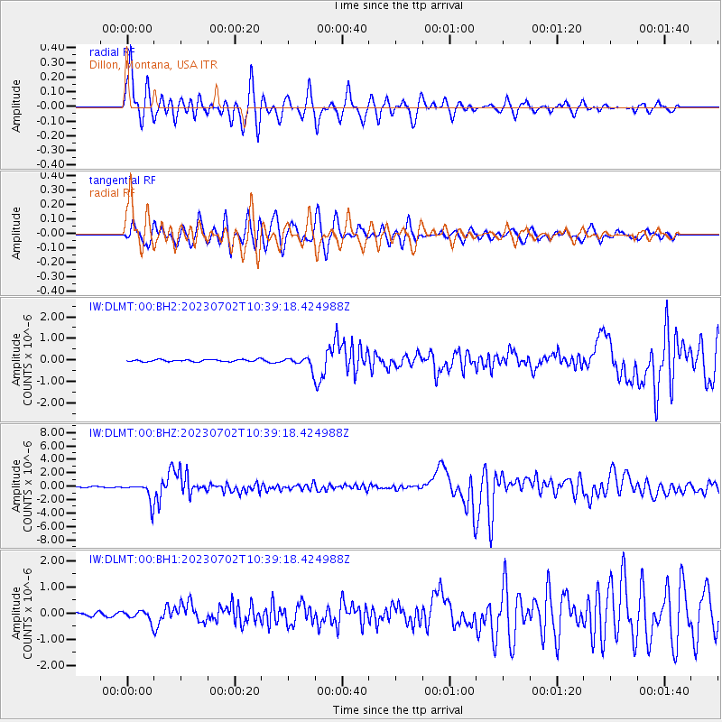
Signal To Noise
| Channel | StoN | STA | LTA |
| IW:DLMT:00:BHZ:20230702T10:39:18.424988Z | 24.058556 | 1.4909799E-6 | 6.197296E-8 |
| IW:DLMT:00:BH1:20230702T10:39:18.424988Z | 4.091767 | 1.949695E-7 | 4.764922E-8 |
| IW:DLMT:00:BH2:20230702T10:39:18.424988Z | 5.1802416 | 2.4328222E-7 | 4.696349E-8 |
| Arrivals |
| Ps | 3.8 SECOND |
| PpPs | 16 SECOND |
| PsPs/PpSs | 19 SECOND |


