You are here: Home > Network List > US - United States National Seismic Network Stations List
> Station TPNV Topopah Spring, Nevada, USA > Earthquake Result Viewer
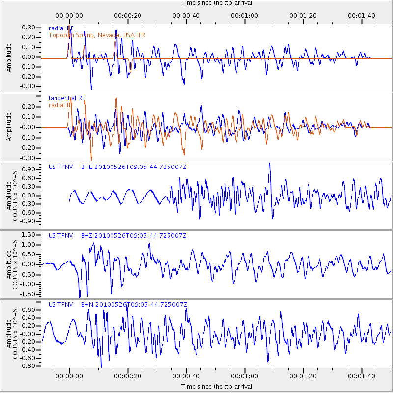
TPNV Topopah Spring, Nevada, USA - Earthquake Result Viewer
*The percent match for this event was below the threshold and hence no stack was calculated.
| Earthquake location: |
Southeast Of Ryukyu Islands |
| Earthquake latitude/longitude: |
25.8/129.9 |
| Earthquake time(UTC): |
2010/05/26 (146) 08:53:08 GMT |
| Earthquake Depth: |
10 km |
| Earthquake Magnitude: |
6.2 MB, 6.2 MS, 6.5 MW, 6.5 MW |
| Earthquake Catalog/Contributor: |
WHDF/NEIC |
|
| Network: |
US United States National Seismic Network |
| Station: |
TPNV Topopah Spring, Nevada, USA |
| Lat/Lon: |
36.95 N/116.25 W |
| Elevation: |
1600 m |
|
| Distance: |
91.9 deg |
| Az: |
47.167 deg |
| Baz: |
304.372 deg |
| Ray Param: |
$rayparam |
*The percent match for this event was below the threshold and hence was not used in the summary stack. |
|
| Radial Match: |
64.79244 % |
| Radial Bump: |
400 |
| Transverse Match: |
61.263897 % |
| Transverse Bump: |
400 |
| SOD ConfigId: |
314592 |
| Insert Time: |
2010-09-14 07:14:12.560 +0000 |
| GWidth: |
2.5 |
| Max Bumps: |
400 |
| Tol: |
0.001 |
|
Signal To Noise
| Channel | StoN | STA | LTA |
| US:TPNV: :BHZ:20100526T09:05:44.725007Z | 6.073484 | 5.7084344E-7 | 9.398945E-8 |
| US:TPNV: :BHN:20100526T09:05:44.725007Z | 1.2200664 | 2.3225131E-7 | 1.9035956E-7 |
| US:TPNV: :BHE:20100526T09:05:44.725007Z | 0.8234741 | 1.2599487E-7 | 1.5300405E-7 |
| Arrivals |
| Ps | |
| PpPs | |
| PsPs/PpSs | |


