You are here: Home > Network List > US - United States National Seismic Network Stations List
> Station AHID Auburn Hatchery, Idaho, USA > Earthquake Result Viewer
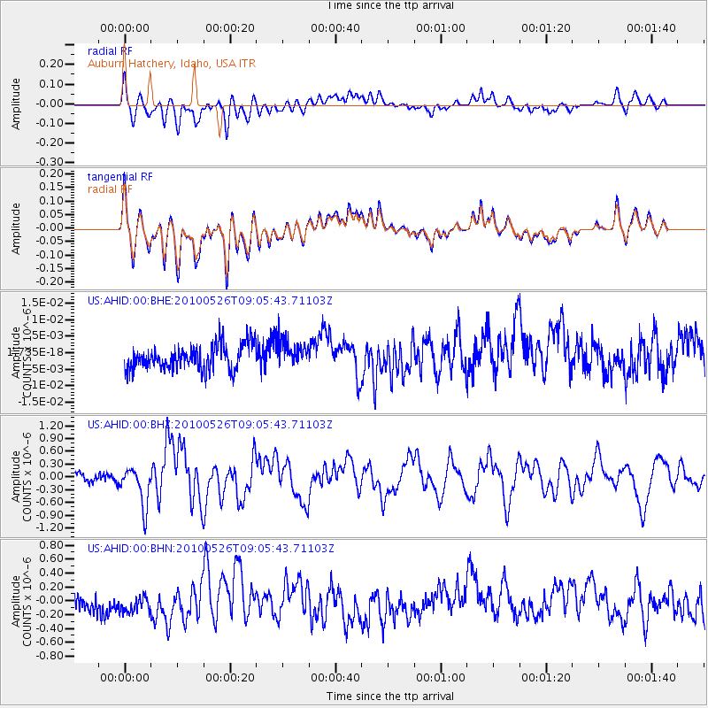
AHID Auburn Hatchery, Idaho, USA - Earthquake Result Viewer
*The percent match for this event was below the threshold and hence no stack was calculated.
| Earthquake location: |
Southeast Of Ryukyu Islands |
| Earthquake latitude/longitude: |
25.8/129.9 |
| Earthquake time(UTC): |
2010/05/26 (146) 08:53:08 GMT |
| Earthquake Depth: |
10 km |
| Earthquake Magnitude: |
6.2 MB, 6.2 MS, 6.5 MW, 6.5 MW |
| Earthquake Catalog/Contributor: |
WHDF/NEIC |
|
| Network: |
US United States National Seismic Network |
| Station: |
AHID Auburn Hatchery, Idaho, USA |
| Lat/Lon: |
42.77 N/111.10 W |
| Elevation: |
1960 m |
|
| Distance: |
91.7 deg |
| Az: |
40.137 deg |
| Baz: |
307.882 deg |
| Ray Param: |
$rayparam |
*The percent match for this event was below the threshold and hence was not used in the summary stack. |
|
| Radial Match: |
60.97696 % |
| Radial Bump: |
400 |
| Transverse Match: |
61.561043 % |
| Transverse Bump: |
400 |
| SOD ConfigId: |
314592 |
| Insert Time: |
2010-09-14 07:15:01.222 +0000 |
| GWidth: |
2.5 |
| Max Bumps: |
400 |
| Tol: |
0.001 |
|
Signal To Noise
| Channel | StoN | STA | LTA |
| US:AHID:00:BHZ:20100526T09:05:43.71103Z | 4.4961677 | 4.6423978E-7 | 1.0325233E-7 |
| US:AHID:00:BHN:20100526T09:05:43.71103Z | 1.2906786 | 1.8101892E-7 | 1.4025096E-7 |
| US:AHID:00:BHE:20100526T09:05:43.71103Z | 1.0523264 | 3.9366075E-9 | 3.7408614E-9 |
| Arrivals |
| Ps | |
| PpPs | |
| PsPs/PpSs | |


