You are here: Home > Network List > O2 - Oklahoma Consolidated Temporary Seismic Networks Stations List
> Station QUIN Quinton, Oklahoma, USA > Earthquake Result Viewer
QUIN Quinton, Oklahoma, USA - Earthquake Result Viewer
| Earthquake location: |
Tonga Islands |
| Earthquake latitude/longitude: |
-17.9/-174.7 |
| Earthquake time(UTC): |
2023/07/02 (183) 10:27:45 GMT |
| Earthquake Depth: |
247 km |
| Earthquake Magnitude: |
6.7 Mi |
| Earthquake Catalog/Contributor: |
NEIC PDE/at |
|
| Network: |
O2 Oklahoma Consolidated Temporary Seismic Networks |
| Station: |
QUIN Quinton, Oklahoma, USA |
| Lat/Lon: |
35.20 N/95.47 W |
| Elevation: |
227 m |
|
| Distance: |
91.7 deg |
| Az: |
53.598 deg |
| Baz: |
249.363 deg |
| Ray Param: |
0.04145182 |
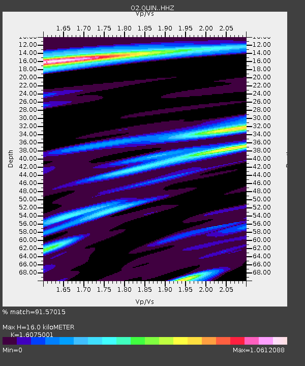
| Estimated Moho Depth: |
16.0 km |
| Estimated Crust Vp/Vs: |
1.61 |
| Assumed Crust Vp: |
6.498 km/s |
| Estimated Crust Vs: |
4.042 km/s |
| Estimated Crust Poisson's Ratio: |
0.18 |
|
| Radial Match: |
91.57015 % |
| Radial Bump: |
400 |
| Transverse Match: |
84.097435 % |
| Transverse Bump: |
400 |
| SOD ConfigId: |
30536071 |
| Insert Time: |
2023-07-16 10:55:14.477 +0000 |
| GWidth: |
2.5 |
| Max Bumps: |
400 |
| Tol: |
0.001 |
|

Signal To Noise
| Channel | StoN | STA | LTA |
| O2:QUIN: :HHZ:20230702T10:39:52.934998Z | 4.049549 | 3.506007E-7 | 8.6577714E-8 |
| O2:QUIN: :HHN:20230702T10:39:52.934998Z | 0.8389837 | 4.1373717E-8 | 4.931409E-8 |
| O2:QUIN: :HHE:20230702T10:39:52.934998Z | 1.0934944 | 7.992304E-8 | 7.308957E-8 |
| Arrivals |
| Ps | 1.5 SECOND |
| PpPs | 6.3 SECOND |
| PsPs/PpSs | 7.8 SECOND |


