You are here: Home > Network List > O2 - Oklahoma Consolidated Temporary Seismic Networks Stations List
> Station SMNL Seminole, Oklahoma, USA > Earthquake Result Viewer
SMNL Seminole, Oklahoma, USA - Earthquake Result Viewer
| Earthquake location: |
Tonga Islands |
| Earthquake latitude/longitude: |
-17.9/-174.7 |
| Earthquake time(UTC): |
2023/07/02 (183) 10:27:45 GMT |
| Earthquake Depth: |
247 km |
| Earthquake Magnitude: |
6.7 Mi |
| Earthquake Catalog/Contributor: |
NEIC PDE/at |
|
| Network: |
O2 Oklahoma Consolidated Temporary Seismic Networks |
| Station: |
SMNL Seminole, Oklahoma, USA |
| Lat/Lon: |
35.29 N/96.56 W |
| Elevation: |
317 m |
|
| Distance: |
90.9 deg |
| Az: |
53.191 deg |
| Baz: |
248.743 deg |
| Ray Param: |
0.041576546 |
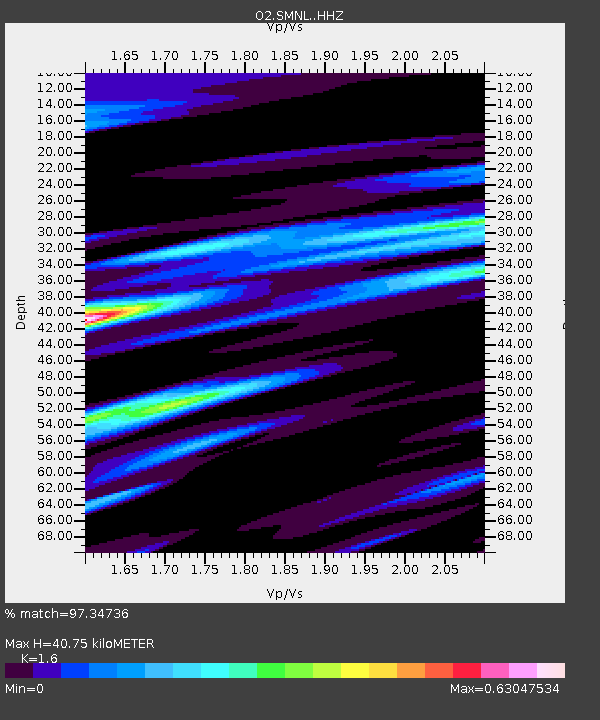
| Estimated Moho Depth: |
40.75 km |
| Estimated Crust Vp/Vs: |
1.60 |
| Assumed Crust Vp: |
6.426 km/s |
| Estimated Crust Vs: |
4.016 km/s |
| Estimated Crust Poisson's Ratio: |
0.18 |
|
| Radial Match: |
97.34736 % |
| Radial Bump: |
341 |
| Transverse Match: |
91.81361 % |
| Transverse Bump: |
381 |
| SOD ConfigId: |
30536071 |
| Insert Time: |
2023-07-16 10:55:42.954 +0000 |
| GWidth: |
2.5 |
| Max Bumps: |
400 |
| Tol: |
0.001 |
|

Signal To Noise
| Channel | StoN | STA | LTA |
| O2:SMNL: :HHZ:20230702T10:39:49.219971Z | 5.400923 | 3.3958815E-7 | 6.2875955E-8 |
| O2:SMNL: :HHN:20230702T10:39:49.219971Z | 1.2944032 | 6.668991E-8 | 5.1521738E-8 |
| O2:SMNL: :HHE:20230702T10:39:49.219971Z | 1.16536 | 7.6638194E-8 | 6.5763544E-8 |
| Arrivals |
| Ps | 3.9 SECOND |
| PpPs | 16 SECOND |
| PsPs/PpSs | 20 SECOND |


