You are here: Home > Network List > UW - Pacific Northwest Regional Seismic Network Stations List
> Station MEGW Megler, WA CREST BB SMO > Earthquake Result Viewer
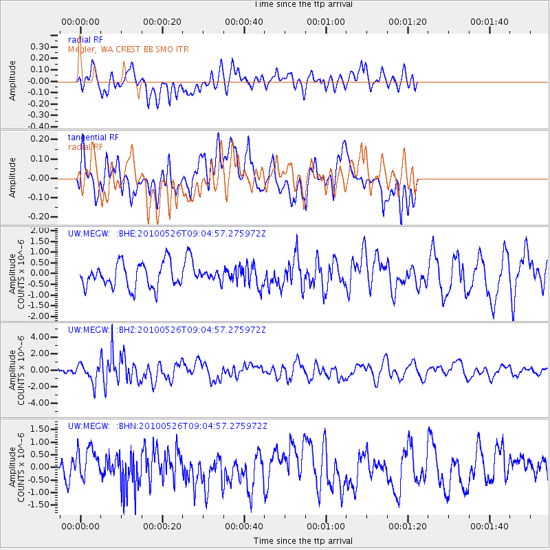
MEGW Megler, WA CREST BB SMO - Earthquake Result Viewer
*The percent match for this event was below the threshold and hence no stack was calculated.
| Earthquake location: |
Southeast Of Ryukyu Islands |
| Earthquake latitude/longitude: |
25.8/129.9 |
| Earthquake time(UTC): |
2010/05/26 (146) 08:53:08 GMT |
| Earthquake Depth: |
10 km |
| Earthquake Magnitude: |
6.2 MB, 6.2 MS, 6.5 MW, 6.5 MW |
| Earthquake Catalog/Contributor: |
WHDF/NEIC |
|
| Network: |
UW Pacific Northwest Regional Seismic Network |
| Station: |
MEGW Megler, WA CREST BB SMO |
| Lat/Lon: |
46.27 N/123.88 W |
| Elevation: |
332 m |
|
| Distance: |
82.1 deg |
| Az: |
42.269 deg |
| Baz: |
299.048 deg |
| Ray Param: |
$rayparam |
*The percent match for this event was below the threshold and hence was not used in the summary stack. |
|
| Radial Match: |
56.329475 % |
| Radial Bump: |
400 |
| Transverse Match: |
64.58004 % |
| Transverse Bump: |
400 |
| SOD ConfigId: |
314592 |
| Insert Time: |
2010-09-14 07:16:10.819 +0000 |
| GWidth: |
2.5 |
| Max Bumps: |
400 |
| Tol: |
0.001 |
|
Signal To Noise
| Channel | StoN | STA | LTA |
| UW:MEGW: :BHZ:20100526T09:04:57.275972Z | 3.0162468 | 1.1195043E-6 | 3.7115805E-7 |
| UW:MEGW: :BHN:20100526T09:04:57.275972Z | 1.095903 | 7.08934E-7 | 6.468948E-7 |
| UW:MEGW: :BHE:20100526T09:04:57.275972Z | 0.36413616 | 2.059844E-7 | 5.656796E-7 |
| Arrivals |
| Ps | |
| PpPs | |
| PsPs/PpSs | |


