You are here: Home > Network List > PQ - Public Safety Geoscience Program Canadian Research Network (PSGP) Stations List
> Station NBC7 Northern British Columbia Site Seven > Earthquake Result Viewer
NBC7 Northern British Columbia Site Seven - Earthquake Result Viewer
| Earthquake location: |
Tonga Islands |
| Earthquake latitude/longitude: |
-17.9/-174.7 |
| Earthquake time(UTC): |
2023/07/02 (183) 10:27:45 GMT |
| Earthquake Depth: |
247 km |
| Earthquake Magnitude: |
6.7 Mi |
| Earthquake Catalog/Contributor: |
NEIC PDE/at |
|
| Network: |
PQ Public Safety Geoscience Program Canadian Research Network (PSGP) |
| Station: |
NBC7 Northern British Columbia Site Seven |
| Lat/Lon: |
56.27 N/120.84 W |
| Elevation: |
676 m |
|
| Distance: |
86.6 deg |
| Az: |
26.829 deg |
| Baz: |
230.383 deg |
| Ray Param: |
0.043357685 |
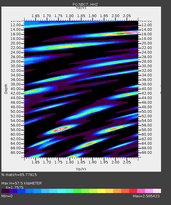
| Estimated Moho Depth: |
57.5 km |
| Estimated Crust Vp/Vs: |
1.76 |
| Assumed Crust Vp: |
6.291 km/s |
| Estimated Crust Vs: |
3.579 km/s |
| Estimated Crust Poisson's Ratio: |
0.26 |
|
| Radial Match: |
85.77615 % |
| Radial Bump: |
400 |
| Transverse Match: |
75.65783 % |
| Transverse Bump: |
400 |
| SOD ConfigId: |
30536071 |
| Insert Time: |
2023-07-16 10:57:02.005 +0000 |
| GWidth: |
2.5 |
| Max Bumps: |
400 |
| Tol: |
0.001 |
|

Signal To Noise
| Channel | StoN | STA | LTA |
| PQ:NBC7: :HHZ:20230702T10:39:29.02002Z | 37.587933 | 2.9270584E-6 | 7.787229E-8 |
| PQ:NBC7: :HH1:20230702T10:39:29.02002Z | 6.3346167 | 8.610521E-7 | 1.3592805E-7 |
| PQ:NBC7: :HH2:20230702T10:39:29.02002Z | 5.8481803 | 8.4780237E-7 | 1.4496857E-7 |
| Arrivals |
| Ps | 7.1 SECOND |
| PpPs | 25 SECOND |
| PsPs/PpSs | 32 SECOND |


