You are here: Home > Network List > PY - PFO Array Stations List
> Station BPH06 Pinon Flat Observatory, CA, USA > Earthquake Result Viewer
BPH06 Pinon Flat Observatory, CA, USA - Earthquake Result Viewer
| Earthquake location: |
Tonga Islands |
| Earthquake latitude/longitude: |
-17.9/-174.7 |
| Earthquake time(UTC): |
2023/07/02 (183) 10:27:45 GMT |
| Earthquake Depth: |
247 km |
| Earthquake Magnitude: |
6.7 Mi |
| Earthquake Catalog/Contributor: |
NEIC PDE/at |
|
| Network: |
PY PFO Array |
| Station: |
BPH06 Pinon Flat Observatory, CA, USA |
| Lat/Lon: |
33.61 N/116.45 W |
| Elevation: |
1294 m |
|
| Distance: |
75.5 deg |
| Az: |
47.127 deg |
| Baz: |
236.741 deg |
| Ray Param: |
0.050945595 |
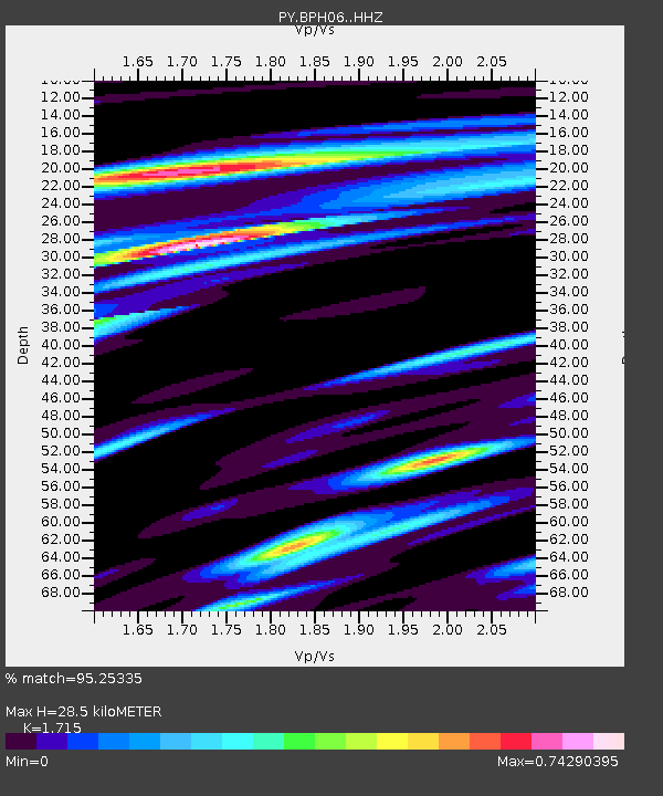
| Estimated Moho Depth: |
28.5 km |
| Estimated Crust Vp/Vs: |
1.72 |
| Assumed Crust Vp: |
6.264 km/s |
| Estimated Crust Vs: |
3.652 km/s |
| Estimated Crust Poisson's Ratio: |
0.24 |
|
| Radial Match: |
95.25335 % |
| Radial Bump: |
372 |
| Transverse Match: |
78.17302 % |
| Transverse Bump: |
400 |
| SOD ConfigId: |
30536071 |
| Insert Time: |
2023-07-16 10:57:34.552 +0000 |
| GWidth: |
2.5 |
| Max Bumps: |
400 |
| Tol: |
0.001 |
|

Signal To Noise
| Channel | StoN | STA | LTA |
| PY:BPH06: :HHZ:20230702T10:38:31.216003Z | 5.5724177 | 6.9535037E-7 | 1.2478432E-7 |
| PY:BPH06: :HHN:20230702T10:38:31.216003Z | 0.89195615 | 1.3830046E-7 | 1.5505299E-7 |
| PY:BPH06: :HHE:20230702T10:38:31.216003Z | 2.753917 | 1.9642137E-7 | 7.132436E-8 |
| Arrivals |
| Ps | 3.4 SECOND |
| PpPs | 12 SECOND |
| PsPs/PpSs | 15 SECOND |


