You are here: Home > Network List > PY - PFO Array Stations List
> Station BPH13 Pinon Flat Observatory, CA, USA > Earthquake Result Viewer
BPH13 Pinon Flat Observatory, CA, USA - Earthquake Result Viewer
| Earthquake location: |
Tonga Islands |
| Earthquake latitude/longitude: |
-17.9/-174.7 |
| Earthquake time(UTC): |
2023/07/02 (183) 10:27:45 GMT |
| Earthquake Depth: |
247 km |
| Earthquake Magnitude: |
6.7 Mi |
| Earthquake Catalog/Contributor: |
NEIC PDE/at |
|
| Network: |
PY PFO Array |
| Station: |
BPH13 Pinon Flat Observatory, CA, USA |
| Lat/Lon: |
33.61 N/116.46 W |
| Elevation: |
1300 m |
|
| Distance: |
75.5 deg |
| Az: |
47.125 deg |
| Baz: |
236.736 deg |
| Ray Param: |
0.050949562 |
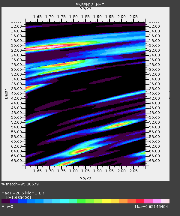
| Estimated Moho Depth: |
20.5 km |
| Estimated Crust Vp/Vs: |
1.69 |
| Assumed Crust Vp: |
6.264 km/s |
| Estimated Crust Vs: |
3.717 km/s |
| Estimated Crust Poisson's Ratio: |
0.23 |
|
| Radial Match: |
95.30679 % |
| Radial Bump: |
389 |
| Transverse Match: |
77.831276 % |
| Transverse Bump: |
400 |
| SOD ConfigId: |
30536071 |
| Insert Time: |
2023-07-16 10:57:46.139 +0000 |
| GWidth: |
2.5 |
| Max Bumps: |
400 |
| Tol: |
0.001 |
|

Signal To Noise
| Channel | StoN | STA | LTA |
| PY:BPH13: :HHZ:20230702T10:38:31.185974Z | 5.1609282 | 7.06698E-7 | 1.3693236E-7 |
| PY:BPH13: :HHN:20230702T10:38:31.185974Z | 0.94315726 | 1.423827E-7 | 1.509639E-7 |
| PY:BPH13: :HHE:20230702T10:38:31.185974Z | 2.7691777 | 1.8987978E-7 | 6.8569015E-8 |
| Arrivals |
| Ps | 2.3 SECOND |
| PpPs | 8.5 SECOND |
| PsPs/PpSs | 11 SECOND |


