You are here: Home > Network List > UW - Pacific Northwest Regional Seismic Network Stations List
> Station MRBL Marblemount, WA, USA > Earthquake Result Viewer
MRBL Marblemount, WA, USA - Earthquake Result Viewer
| Earthquake location: |
Southeast Of Ryukyu Islands |
| Earthquake latitude/longitude: |
25.8/129.9 |
| Earthquake time(UTC): |
2010/05/26 (146) 08:53:08 GMT |
| Earthquake Depth: |
10 km |
| Earthquake Magnitude: |
6.2 MB, 6.2 MS, 6.5 MW, 6.5 MW |
| Earthquake Catalog/Contributor: |
WHDF/NEIC |
|
| Network: |
UW Pacific Northwest Regional Seismic Network |
| Station: |
MRBL Marblemount, WA, USA |
| Lat/Lon: |
48.52 N/121.48 W |
| Elevation: |
75 m |
|
| Distance: |
82.4 deg |
| Az: |
39.481 deg |
| Baz: |
300.428 deg |
| Ray Param: |
0.04690667 |
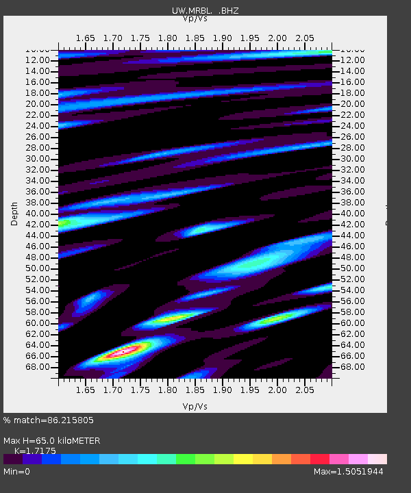
| Estimated Moho Depth: |
65.0 km |
| Estimated Crust Vp/Vs: |
1.72 |
| Assumed Crust Vp: |
6.566 km/s |
| Estimated Crust Vs: |
3.823 km/s |
| Estimated Crust Poisson's Ratio: |
0.24 |
|
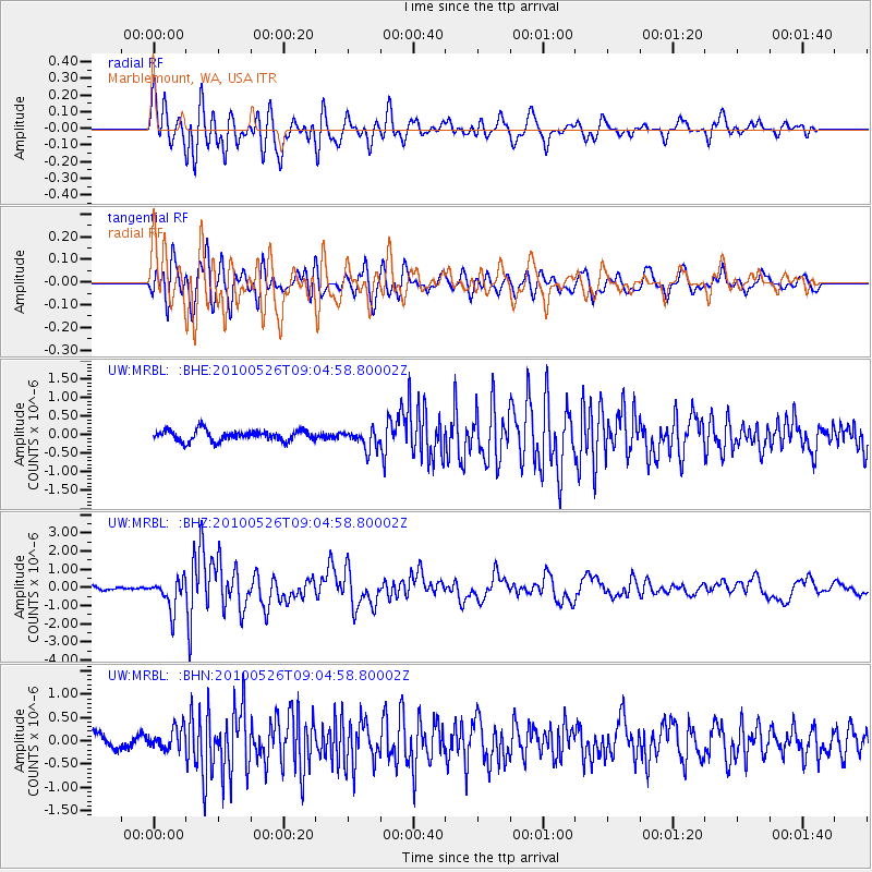
| Radial Match: |
86.215805 % |
| Radial Bump: |
400 |
| Transverse Match: |
75.4925 % |
| Transverse Bump: |
400 |
| SOD ConfigId: |
314592 |
| Insert Time: |
2010-09-14 07:16:37.807 +0000 |
| GWidth: |
2.5 |
| Max Bumps: |
400 |
| Tol: |
0.001 |
|
Signal To Noise
| Channel | StoN | STA | LTA |
| UW:MRBL: :BHZ:20100526T09:04:58.80002Z | 6.817439 | 8.4253094E-7 | 1.2358467E-7 |
| UW:MRBL: :BHN:20100526T09:04:58.80002Z | 0.98100644 | 2.3437896E-7 | 2.3891684E-7 |
| UW:MRBL: :BHE:20100526T09:04:58.80002Z | 1.8150352 | 2.5874715E-7 | 1.4255764E-7 |
| Arrivals |
| Ps | 7.3 SECOND |
| PpPs | 26 SECOND |
| PsPs/PpSs | 33 SECOND |


