You are here: Home > Network List > RV - Regional Alberta Seismic Observatory for Earthquake Studies Network Stations List
> Station LGPLA Lodgepole, AB > Earthquake Result Viewer
LGPLA Lodgepole, AB - Earthquake Result Viewer
| Earthquake location: |
Tonga Islands |
| Earthquake latitude/longitude: |
-17.9/-174.7 |
| Earthquake time(UTC): |
2023/07/02 (183) 10:27:45 GMT |
| Earthquake Depth: |
247 km |
| Earthquake Magnitude: |
6.7 Mi |
| Earthquake Catalog/Contributor: |
NEIC PDE/at |
|
| Network: |
RV Regional Alberta Seismic Observatory for Earthquake Studies Network |
| Station: |
LGPLA Lodgepole, AB |
| Lat/Lon: |
53.11 N/115.36 W |
| Elevation: |
886 m |
|
| Distance: |
87.2 deg |
| Az: |
31.277 deg |
| Baz: |
235.096 deg |
| Ray Param: |
0.042909216 |
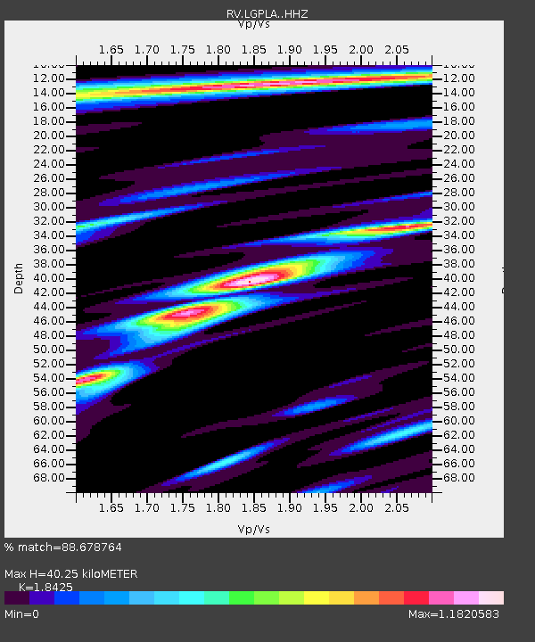
| Estimated Moho Depth: |
40.25 km |
| Estimated Crust Vp/Vs: |
1.84 |
| Assumed Crust Vp: |
6.426 km/s |
| Estimated Crust Vs: |
3.488 km/s |
| Estimated Crust Poisson's Ratio: |
0.29 |
|
| Radial Match: |
88.678764 % |
| Radial Bump: |
400 |
| Transverse Match: |
82.51187 % |
| Transverse Bump: |
400 |
| SOD ConfigId: |
30536071 |
| Insert Time: |
2023-07-16 10:58:23.473 +0000 |
| GWidth: |
2.5 |
| Max Bumps: |
400 |
| Tol: |
0.001 |
|

Signal To Noise
| Channel | StoN | STA | LTA |
| RV:LGPLA: :HHZ:20230702T10:39:32.01001Z | 24.967684 | 2.019072E-6 | 8.0867416E-8 |
| RV:LGPLA: :HHN:20230702T10:39:32.01001Z | 3.8549483 | 3.1495696E-7 | 8.170199E-8 |
| RV:LGPLA: :HHE:20230702T10:39:32.01001Z | 4.7804513 | 5.4590674E-7 | 1.1419566E-7 |
| Arrivals |
| Ps | 5.4 SECOND |
| PpPs | 17 SECOND |
| PsPs/PpSs | 23 SECOND |


