You are here: Home > Network List > UO - University of Oregon Regional Network Stations List
> Station DING Powers, OR, USA > Earthquake Result Viewer
DING Powers, OR, USA - Earthquake Result Viewer
| Earthquake location: |
Tonga Islands |
| Earthquake latitude/longitude: |
-17.9/-174.7 |
| Earthquake time(UTC): |
2023/07/02 (183) 10:27:45 GMT |
| Earthquake Depth: |
247 km |
| Earthquake Magnitude: |
6.7 Mi |
| Earthquake Catalog/Contributor: |
NEIC PDE/at |
|
| Network: |
UO University of Oregon Regional Network |
| Station: |
DING Powers, OR, USA |
| Lat/Lon: |
42.86 N/124.05 W |
| Elevation: |
100 m |
|
| Distance: |
76.3 deg |
| Az: |
35.817 deg |
| Baz: |
229.275 deg |
| Ray Param: |
0.050433263 |
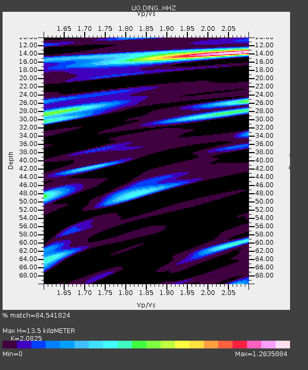
| Estimated Moho Depth: |
13.5 km |
| Estimated Crust Vp/Vs: |
2.08 |
| Assumed Crust Vp: |
6.048 km/s |
| Estimated Crust Vs: |
2.904 km/s |
| Estimated Crust Poisson's Ratio: |
0.35 |
|
| Radial Match: |
84.541824 % |
| Radial Bump: |
400 |
| Transverse Match: |
79.61798 % |
| Transverse Bump: |
400 |
| SOD ConfigId: |
30536071 |
| Insert Time: |
2023-07-16 11:02:11.721 +0000 |
| GWidth: |
2.5 |
| Max Bumps: |
400 |
| Tol: |
0.001 |
|

Signal To Noise
| Channel | StoN | STA | LTA |
| UO:DING: :HHZ:20230702T10:38:35.52002Z | 4.736199 | 1.6548937E-6 | 3.494139E-7 |
| UO:DING: :HHN:20230702T10:38:35.52002Z | 1.1477934 | 4.6852594E-7 | 4.081971E-7 |
| UO:DING: :HHE:20230702T10:38:35.52002Z | 1.0218762 | 3.7356875E-7 | 3.6557142E-7 |
| Arrivals |
| Ps | 2.5 SECOND |
| PpPs | 6.7 SECOND |
| PsPs/PpSs | 9.2 SECOND |


