You are here: Home > Network List > UO - University of Oregon Regional Network Stations List
> Station VINO Umpqua, OR, USA > Earthquake Result Viewer
VINO Umpqua, OR, USA - Earthquake Result Viewer
| Earthquake location: |
Tonga Islands |
| Earthquake latitude/longitude: |
-17.9/-174.7 |
| Earthquake time(UTC): |
2023/07/02 (183) 10:27:45 GMT |
| Earthquake Depth: |
247 km |
| Earthquake Magnitude: |
6.7 Mi |
| Earthquake Catalog/Contributor: |
NEIC PDE/at |
|
| Network: |
UO University of Oregon Regional Network |
| Station: |
VINO Umpqua, OR, USA |
| Lat/Lon: |
43.43 N/123.42 W |
| Elevation: |
319 m |
|
| Distance: |
77.0 deg |
| Az: |
35.684 deg |
| Baz: |
229.675 deg |
| Ray Param: |
0.049961265 |
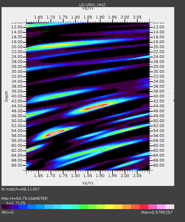
| Estimated Moho Depth: |
54.75 km |
| Estimated Crust Vp/Vs: |
1.71 |
| Assumed Crust Vp: |
6.522 km/s |
| Estimated Crust Vs: |
3.808 km/s |
| Estimated Crust Poisson's Ratio: |
0.24 |
|
| Radial Match: |
86.11407 % |
| Radial Bump: |
400 |
| Transverse Match: |
83.49594 % |
| Transverse Bump: |
400 |
| SOD ConfigId: |
30536071 |
| Insert Time: |
2023-07-16 11:03:25.795 +0000 |
| GWidth: |
2.5 |
| Max Bumps: |
400 |
| Tol: |
0.001 |
|

Signal To Noise
| Channel | StoN | STA | LTA |
| UO:VINO: :HHZ:20230702T10:38:39.530029Z | 7.254934 | 1.7364077E-6 | 2.3934163E-7 |
| UO:VINO: :HHN:20230702T10:38:39.530029Z | 1.2952985 | 4.2012454E-7 | 3.2434573E-7 |
| UO:VINO: :HHE:20230702T10:38:39.530029Z | 2.4251103 | 3.4732565E-7 | 1.4322056E-7 |
| Arrivals |
| Ps | 6.2 SECOND |
| PpPs | 22 SECOND |
| PsPs/PpSs | 28 SECOND |


