You are here: Home > Network List > UO - University of Oregon Regional Network Stations List
> Station GROND Grand Ronde, OR, USA > Earthquake Result Viewer
GROND Grand Ronde, OR, USA - Earthquake Result Viewer
| Earthquake location: |
Tonga Islands |
| Earthquake latitude/longitude: |
-17.9/-174.7 |
| Earthquake time(UTC): |
2023/07/02 (183) 10:27:45 GMT |
| Earthquake Depth: |
247 km |
| Earthquake Magnitude: |
6.7 Mi |
| Earthquake Catalog/Contributor: |
NEIC PDE/at |
|
| Network: |
UO University of Oregon Regional Network |
| Station: |
GROND Grand Ronde, OR, USA |
| Lat/Lon: |
45.03 N/123.69 W |
| Elevation: |
478 m |
|
| Distance: |
77.9 deg |
| Az: |
34.31 deg |
| Baz: |
229.189 deg |
| Ray Param: |
0.049356367 |
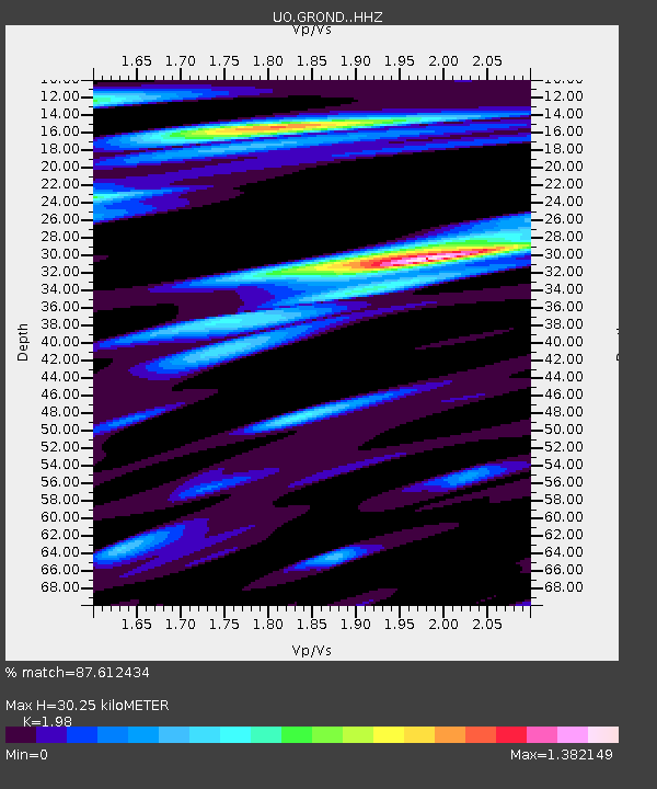
| Estimated Moho Depth: |
30.25 km |
| Estimated Crust Vp/Vs: |
1.98 |
| Assumed Crust Vp: |
6.566 km/s |
| Estimated Crust Vs: |
3.316 km/s |
| Estimated Crust Poisson's Ratio: |
0.33 |
|
| Radial Match: |
87.612434 % |
| Radial Bump: |
400 |
| Transverse Match: |
77.26223 % |
| Transverse Bump: |
400 |
| SOD ConfigId: |
30536071 |
| Insert Time: |
2023-07-16 11:03:42.392 +0000 |
| GWidth: |
2.5 |
| Max Bumps: |
400 |
| Tol: |
0.001 |
|

Signal To Noise
| Channel | StoN | STA | LTA |
| UO:GROND: :HHZ:20230702T10:38:44.440002Z | 4.7242327 | 1.8188814E-6 | 3.8501094E-7 |
| UO:GROND: :HHN:20230702T10:38:44.440002Z | 1.5111413 | 3.906493E-7 | 2.5851276E-7 |
| UO:GROND: :HHE:20230702T10:38:44.440002Z | 1.9377121 | 4.38266E-7 | 2.2617705E-7 |
| Arrivals |
| Ps | 4.6 SECOND |
| PpPs | 13 SECOND |
| PsPs/PpSs | 18 SECOND |


