You are here: Home > Network List > US - United States National Seismic Network Stations List
> Station WVOR Wild Horse Valley, Oregon, USA > Earthquake Result Viewer
WVOR Wild Horse Valley, Oregon, USA - Earthquake Result Viewer
| Earthquake location: |
Tonga Islands |
| Earthquake latitude/longitude: |
-17.9/-174.7 |
| Earthquake time(UTC): |
2023/07/02 (183) 10:27:45 GMT |
| Earthquake Depth: |
247 km |
| Earthquake Magnitude: |
6.7 Mi |
| Earthquake Catalog/Contributor: |
NEIC PDE/at |
|
| Network: |
US United States National Seismic Network |
| Station: |
WVOR Wild Horse Valley, Oregon, USA |
| Lat/Lon: |
42.43 N/118.64 W |
| Elevation: |
1344 m |
|
| Distance: |
79.2 deg |
| Az: |
38.709 deg |
| Baz: |
233.549 deg |
| Ray Param: |
0.04852172 |
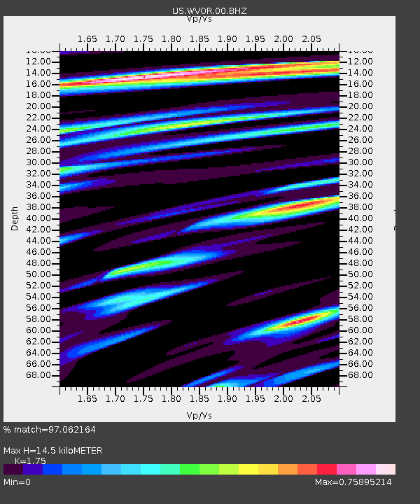
| Estimated Moho Depth: |
14.5 km |
| Estimated Crust Vp/Vs: |
1.75 |
| Assumed Crust Vp: |
6.279 km/s |
| Estimated Crust Vs: |
3.588 km/s |
| Estimated Crust Poisson's Ratio: |
0.26 |
|
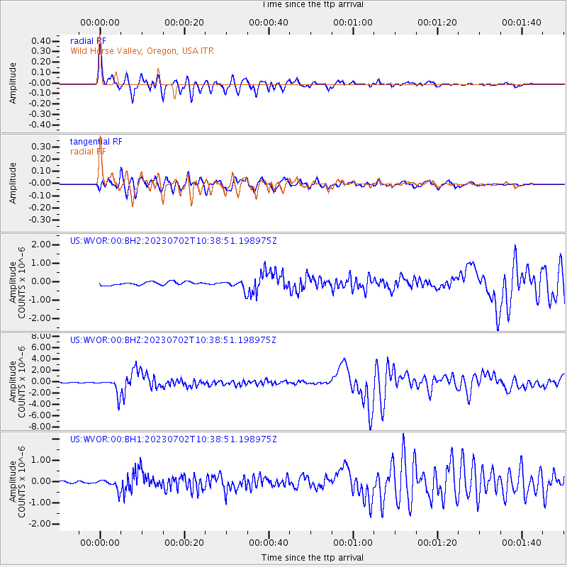
| Radial Match: |
97.062164 % |
| Radial Bump: |
365 |
| Transverse Match: |
94.037735 % |
| Transverse Bump: |
400 |
| SOD ConfigId: |
30536071 |
| Insert Time: |
2023-07-16 11:04:33.156 +0000 |
| GWidth: |
2.5 |
| Max Bumps: |
400 |
| Tol: |
0.001 |
|
Signal To Noise
| Channel | StoN | STA | LTA |
| US:WVOR:00:BHZ:20230702T10:38:51.198975Z | 18.587172 | 1.4547825E-6 | 7.826809E-8 |
| US:WVOR:00:BH1:20230702T10:38:51.198975Z | 3.719904 | 2.4772342E-7 | 6.659403E-8 |
| US:WVOR:00:BH2:20230702T10:38:51.198975Z | 3.0869958 | 2.6852607E-7 | 8.6986205E-8 |
| Arrivals |
| Ps | 1.8 SECOND |
| PpPs | 6.2 SECOND |
| PsPs/PpSs | 8.0 SECOND |


