You are here: Home > Network List > UU - University of Utah Regional Network Stations List
> Station NLU North Lily, UT, USA > Earthquake Result Viewer
NLU North Lily, UT, USA - Earthquake Result Viewer
| Earthquake location: |
Tonga Islands |
| Earthquake latitude/longitude: |
-17.9/-174.7 |
| Earthquake time(UTC): |
2023/07/02 (183) 10:27:45 GMT |
| Earthquake Depth: |
247 km |
| Earthquake Magnitude: |
6.7 Mi |
| Earthquake Catalog/Contributor: |
NEIC PDE/at |
|
| Network: |
UU University of Utah Regional Network |
| Station: |
NLU North Lily, UT, USA |
| Lat/Lon: |
39.95 N/112.07 W |
| Elevation: |
2036 m |
|
| Distance: |
81.9 deg |
| Az: |
43.59 deg |
| Baz: |
238.662 deg |
| Ray Param: |
0.04665586 |
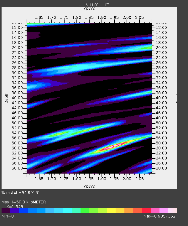
| Estimated Moho Depth: |
59.0 km |
| Estimated Crust Vp/Vs: |
1.95 |
| Assumed Crust Vp: |
6.276 km/s |
| Estimated Crust Vs: |
3.227 km/s |
| Estimated Crust Poisson's Ratio: |
0.32 |
|
| Radial Match: |
94.90161 % |
| Radial Bump: |
400 |
| Transverse Match: |
92.850655 % |
| Transverse Bump: |
357 |
| SOD ConfigId: |
30536071 |
| Insert Time: |
2023-07-16 11:05:03.116 +0000 |
| GWidth: |
2.5 |
| Max Bumps: |
400 |
| Tol: |
0.001 |
|

Signal To Noise
| Channel | StoN | STA | LTA |
| UU:NLU:01:HHZ:20230702T10:39:05.609985Z | 7.9634733 | 5.379488E-7 | 6.755203E-8 |
| UU:NLU:01:HHN:20230702T10:39:05.609985Z | 0.7960685 | 6.0581065E-8 | 7.610032E-8 |
| UU:NLU:01:HHE:20230702T10:39:05.609985Z | 1.6974468 | 1.7763209E-7 | 1.0464663E-7 |
| Arrivals |
| Ps | 9.1 SECOND |
| PpPs | 27 SECOND |
| PsPs/PpSs | 36 SECOND |


