You are here: Home > Network List > UW - Pacific Northwest Regional Seismic Network Stations List
> Station CDF Cedar Flats, MSH, WA, USA > Earthquake Result Viewer
CDF Cedar Flats, MSH, WA, USA - Earthquake Result Viewer
| Earthquake location: |
Tonga Islands |
| Earthquake latitude/longitude: |
-17.9/-174.7 |
| Earthquake time(UTC): |
2023/07/02 (183) 10:27:45 GMT |
| Earthquake Depth: |
247 km |
| Earthquake Magnitude: |
6.7 Mi |
| Earthquake Catalog/Contributor: |
NEIC PDE/at |
|
| Network: |
UW Pacific Northwest Regional Seismic Network |
| Station: |
CDF Cedar Flats, MSH, WA, USA |
| Lat/Lon: |
46.12 N/122.05 W |
| Elevation: |
772 m |
|
| Distance: |
79.5 deg |
| Az: |
34.223 deg |
| Baz: |
230.344 deg |
| Ray Param: |
0.048288114 |
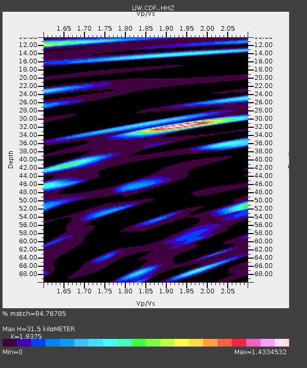
| Estimated Moho Depth: |
31.5 km |
| Estimated Crust Vp/Vs: |
1.94 |
| Assumed Crust Vp: |
6.566 km/s |
| Estimated Crust Vs: |
3.389 km/s |
| Estimated Crust Poisson's Ratio: |
0.32 |
|
| Radial Match: |
94.76785 % |
| Radial Bump: |
400 |
| Transverse Match: |
90.57679 % |
| Transverse Bump: |
400 |
| SOD ConfigId: |
30536071 |
| Insert Time: |
2023-07-16 11:05:39.737 +0000 |
| GWidth: |
2.5 |
| Max Bumps: |
400 |
| Tol: |
0.001 |
|

Signal To Noise
| Channel | StoN | STA | LTA |
| UW:CDF: :HHZ:20230702T10:38:53.02002Z | 19.275562 | 1.9059905E-6 | 9.888119E-8 |
| UW:CDF: :HHN:20230702T10:38:53.02002Z | 8.051758 | 6.06867E-7 | 7.537075E-8 |
| UW:CDF: :HHE:20230702T10:38:53.02002Z | 5.9665976 | 5.326852E-7 | 8.9277876E-8 |
| Arrivals |
| Ps | 4.6 SECOND |
| PpPs | 14 SECOND |
| PsPs/PpSs | 18 SECOND |


