You are here: Home > Network List > UW - Pacific Northwest Regional Seismic Network Stations List
> Station FORK Forks, WA, USA > Earthquake Result Viewer
FORK Forks, WA, USA - Earthquake Result Viewer
| Earthquake location: |
Tonga Islands |
| Earthquake latitude/longitude: |
-17.9/-174.7 |
| Earthquake time(UTC): |
2023/07/02 (183) 10:27:45 GMT |
| Earthquake Depth: |
247 km |
| Earthquake Magnitude: |
6.7 Mi |
| Earthquake Catalog/Contributor: |
NEIC PDE/at |
|
| Network: |
UW Pacific Northwest Regional Seismic Network |
| Station: |
FORK Forks, WA, USA |
| Lat/Lon: |
47.95 N/124.57 W |
| Elevation: |
45 m |
|
| Distance: |
79.4 deg |
| Az: |
31.668 deg |
| Baz: |
228.037 deg |
| Ray Param: |
0.048362877 |
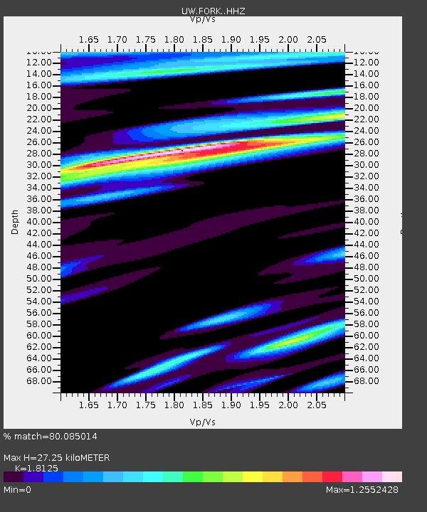
| Estimated Moho Depth: |
27.25 km |
| Estimated Crust Vp/Vs: |
1.81 |
| Assumed Crust Vp: |
6.134 km/s |
| Estimated Crust Vs: |
3.384 km/s |
| Estimated Crust Poisson's Ratio: |
0.28 |
|
| Radial Match: |
80.085014 % |
| Radial Bump: |
400 |
| Transverse Match: |
73.028854 % |
| Transverse Bump: |
400 |
| SOD ConfigId: |
30536071 |
| Insert Time: |
2023-07-16 11:06:21.518 +0000 |
| GWidth: |
2.5 |
| Max Bumps: |
400 |
| Tol: |
0.001 |
|

Signal To Noise
| Channel | StoN | STA | LTA |
| UW:FORK: :HHZ:20230702T10:38:52.450012Z | 3.8653548 | 2.5569445E-6 | 6.615032E-7 |
| UW:FORK: :HHN:20230702T10:38:52.450012Z | 0.6381566 | 5.117465E-7 | 8.0191376E-7 |
| UW:FORK: :HHE:20230702T10:38:52.450012Z | 0.85666656 | 6.033513E-7 | 7.0430116E-7 |
| Arrivals |
| Ps | 3.7 SECOND |
| PpPs | 12 SECOND |
| PsPs/PpSs | 16 SECOND |


