You are here: Home > Network List > GT - Global Telemetered Seismograph Network (USAF/USGS) Stations List
> Station LPAZ La Paz , Bolivia > Earthquake Result Viewer
LPAZ La Paz , Bolivia - Earthquake Result Viewer
| Earthquake location: |
South Sandwich Islands Region |
| Earthquake latitude/longitude: |
-56.8/-25.4 |
| Earthquake time(UTC): |
2018/11/15 (319) 20:02:21 GMT |
| Earthquake Depth: |
10 km |
| Earthquake Magnitude: |
6.3 mww |
| Earthquake Catalog/Contributor: |
NEIC PDE/us |
|
| Network: |
GT Global Telemetered Seismograph Network (USAF/USGS) |
| Station: |
LPAZ La Paz , Bolivia |
| Lat/Lon: |
16.17 S/68.08 W |
| Elevation: |
4817 m |
|
| Distance: |
51.7 deg |
| Az: |
303.866 deg |
| Baz: |
151.598 deg |
| Ray Param: |
0.06724742 |
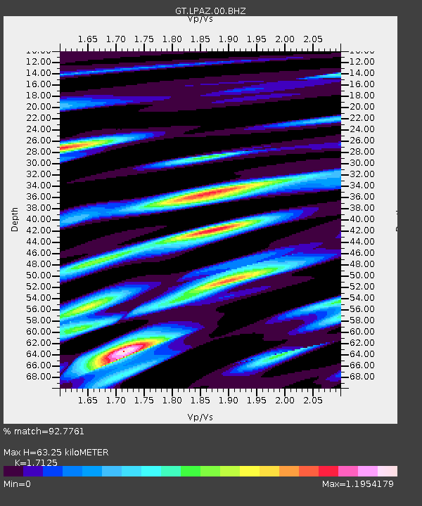
| Estimated Moho Depth: |
63.25 km |
| Estimated Crust Vp/Vs: |
1.71 |
| Assumed Crust Vp: |
6.454 km/s |
| Estimated Crust Vs: |
3.769 km/s |
| Estimated Crust Poisson's Ratio: |
0.24 |
|
| Radial Match: |
92.7761 % |
| Radial Bump: |
400 |
| Transverse Match: |
83.04214 % |
| Transverse Bump: |
400 |
| SOD ConfigId: |
3165032 |
| Insert Time: |
2018-11-29 20:12:28.237 +0000 |
| GWidth: |
2.5 |
| Max Bumps: |
400 |
| Tol: |
0.001 |
|
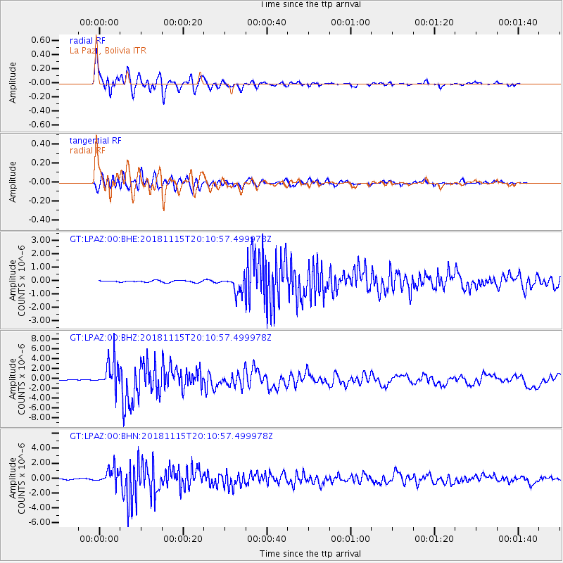
Signal To Noise
| Channel | StoN | STA | LTA |
| GT:LPAZ:00:BHZ:20181115T20:10:57.499978Z | 34.08695 | 2.8824352E-6 | 8.456126E-8 |
| GT:LPAZ:00:BHN:20181115T20:10:57.499978Z | 16.184175 | 1.0646844E-6 | 6.5785514E-8 |
| GT:LPAZ:00:BHE:20181115T20:10:57.499978Z | 12.118794 | 8.1190547E-7 | 6.699557E-8 |
| Arrivals |
| Ps | 7.4 SECOND |
| PpPs | 25 SECOND |
| PsPs/PpSs | 32 SECOND |


