You are here: Home > Network List > AT - Alaska Tsunami Warning Seismic System Stations List
> Station SMY Shemya, Alaska > Earthquake Result Viewer
SMY Shemya, Alaska - Earthquake Result Viewer
| Earthquake location: |
Vanuatu Islands |
| Earthquake latitude/longitude: |
-13.7/166.6 |
| Earthquake time(UTC): |
2010/05/27 (147) 17:14:46 GMT |
| Earthquake Depth: |
31 km |
| Earthquake Magnitude: |
6.2 MB, 7.1 MS, 7.1 MW, 7.0 MW |
| Earthquake Catalog/Contributor: |
WHDF/NEIC |
|
| Network: |
AT Alaska Tsunami Warning Seismic System |
| Station: |
SMY Shemya, Alaska |
| Lat/Lon: |
52.73 N/174.10 E |
| Elevation: |
58 m |
|
| Distance: |
66.5 deg |
| Az: |
4.94 deg |
| Baz: |
187.911 deg |
| Ray Param: |
0.057549 |
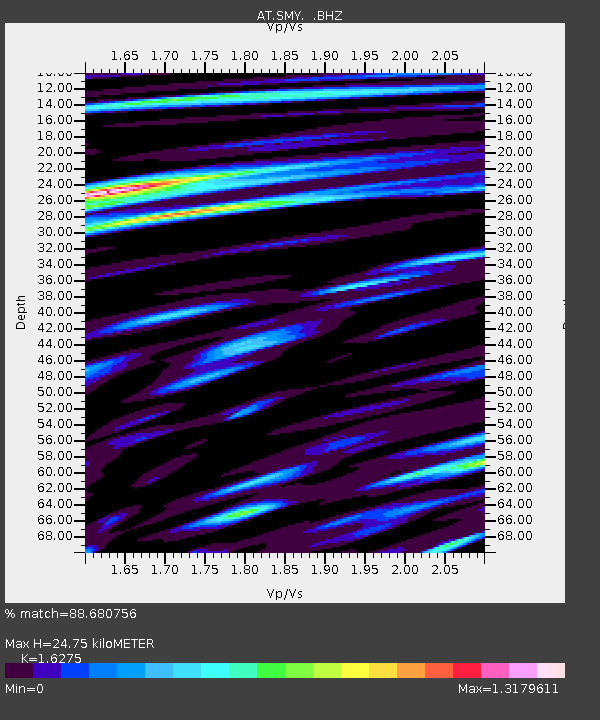
| Estimated Moho Depth: |
24.75 km |
| Estimated Crust Vp/Vs: |
1.63 |
| Assumed Crust Vp: |
3.999 km/s |
| Estimated Crust Vs: |
2.457 km/s |
| Estimated Crust Poisson's Ratio: |
0.20 |
|
| Radial Match: |
88.680756 % |
| Radial Bump: |
400 |
| Transverse Match: |
69.47297 % |
| Transverse Bump: |
400 |
| SOD ConfigId: |
314592 |
| Insert Time: |
2010-09-14 07:19:30.185 +0000 |
| GWidth: |
2.5 |
| Max Bumps: |
400 |
| Tol: |
0.001 |
|

Signal To Noise
| Channel | StoN | STA | LTA |
| AT:SMY: :BHZ:20100527T17:25:02.100029Z | 9.339576 | 8.474006E-6 | 9.073223E-7 |
| AT:SMY: :BHN:20100527T17:25:02.100029Z | 2.7457988 | 3.9996285E-6 | 1.4566357E-6 |
| AT:SMY: :BHE:20100527T17:25:02.100029Z | 1.3882077 | 1.9104614E-6 | 1.3762071E-6 |
| Arrivals |
| Ps | 3.9 SECOND |
| PpPs | 16 SECOND |
| PsPs/PpSs | 20 SECOND |


