You are here: Home > Network List > UW - Pacific Northwest Regional Seismic Network Stations List
> Station HOQUI City of Hoquiam Watershed, Hoquiam, WA, USA > Earthquake Result Viewer
HOQUI City of Hoquiam Watershed, Hoquiam, WA, USA - Earthquake Result Viewer
| Earthquake location: |
Tonga Islands |
| Earthquake latitude/longitude: |
-17.9/-174.7 |
| Earthquake time(UTC): |
2023/07/02 (183) 10:27:45 GMT |
| Earthquake Depth: |
247 km |
| Earthquake Magnitude: |
6.7 Mi |
| Earthquake Catalog/Contributor: |
NEIC PDE/at |
|
| Network: |
UW Pacific Northwest Regional Seismic Network |
| Station: |
HOQUI City of Hoquiam Watershed, Hoquiam, WA, USA |
| Lat/Lon: |
47.08 N/123.96 W |
| Elevation: |
101 m |
|
| Distance: |
79.1 deg |
| Az: |
32.607 deg |
| Baz: |
228.66 deg |
| Ray Param: |
0.04854555 |
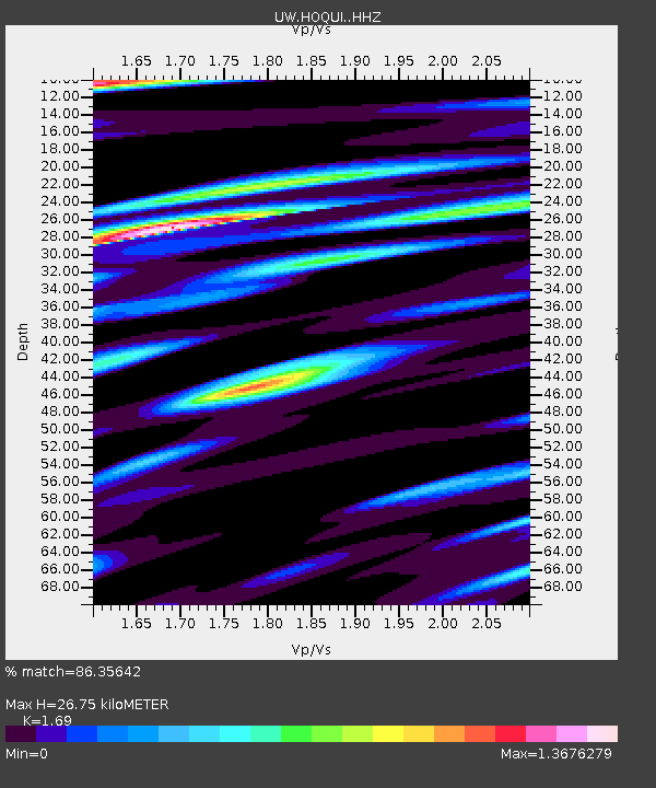
| Estimated Moho Depth: |
26.75 km |
| Estimated Crust Vp/Vs: |
1.69 |
| Assumed Crust Vp: |
6.566 km/s |
| Estimated Crust Vs: |
3.885 km/s |
| Estimated Crust Poisson's Ratio: |
0.23 |
|
| Radial Match: |
86.35642 % |
| Radial Bump: |
400 |
| Transverse Match: |
90.92255 % |
| Transverse Bump: |
400 |
| SOD ConfigId: |
30536071 |
| Insert Time: |
2023-07-16 11:06:42.131 +0000 |
| GWidth: |
2.5 |
| Max Bumps: |
400 |
| Tol: |
0.001 |
|

Signal To Noise
| Channel | StoN | STA | LTA |
| UW:HOQUI: :HHZ:20230702T10:38:51.01001Z | 10.383507 | 2.2975685E-6 | 2.2127097E-7 |
| UW:HOQUI: :HHN:20230702T10:38:51.01001Z | 1.0774387 | 4.1580478E-7 | 3.8591966E-7 |
| UW:HOQUI: :HHE:20230702T10:38:51.01001Z | 1.527332 | 4.999307E-7 | 3.2732288E-7 |
| Arrivals |
| Ps | 2.9 SECOND |
| PpPs | 11 SECOND |
| PsPs/PpSs | 14 SECOND |


