You are here: Home > Network List > UW - Pacific Northwest Regional Seismic Network Stations List
> Station KENT Carlson Farm, Grass Valley, OR, USA > Earthquake Result Viewer
KENT Carlson Farm, Grass Valley, OR, USA - Earthquake Result Viewer
| Earthquake location: |
Tonga Islands |
| Earthquake latitude/longitude: |
-17.9/-174.7 |
| Earthquake time(UTC): |
2023/07/02 (183) 10:27:45 GMT |
| Earthquake Depth: |
247 km |
| Earthquake Magnitude: |
6.7 Mi |
| Earthquake Catalog/Contributor: |
NEIC PDE/at |
|
| Network: |
UW Pacific Northwest Regional Seismic Network |
| Station: |
KENT Carlson Farm, Grass Valley, OR, USA |
| Lat/Lon: |
45.24 N/120.64 W |
| Elevation: |
780 m |
|
| Distance: |
79.7 deg |
| Az: |
35.553 deg |
| Baz: |
231.59 deg |
| Ray Param: |
0.04814492 |
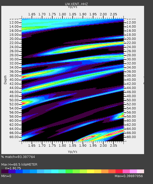
| Estimated Moho Depth: |
68.5 km |
| Estimated Crust Vp/Vs: |
1.92 |
| Assumed Crust Vp: |
6.597 km/s |
| Estimated Crust Vs: |
3.441 km/s |
| Estimated Crust Poisson's Ratio: |
0.31 |
|
| Radial Match: |
93.387764 % |
| Radial Bump: |
370 |
| Transverse Match: |
90.26505 % |
| Transverse Bump: |
400 |
| SOD ConfigId: |
30536071 |
| Insert Time: |
2023-07-16 11:06:52.031 +0000 |
| GWidth: |
2.5 |
| Max Bumps: |
400 |
| Tol: |
0.001 |
|
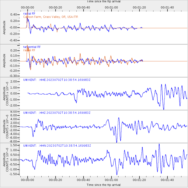
Signal To Noise
| Channel | StoN | STA | LTA |
| UW:KENT: :HHZ:20230702T10:38:54.169983Z | 19.253681 | 1.8837309E-6 | 9.7837436E-8 |
| UW:KENT: :HHN:20230702T10:38:54.169983Z | 4.1259456 | 3.1870343E-7 | 7.724373E-8 |
| UW:KENT: :HHE:20230702T10:38:54.169983Z | 4.5733657 | 4.9595644E-7 | 1.0844452E-7 |
| Arrivals |
| Ps | 9.8 SECOND |
| PpPs | 29 SECOND |
| PsPs/PpSs | 39 SECOND |


