You are here: Home > Network List > UW - Pacific Northwest Regional Seismic Network Stations List
> Station MULN Lyman, WA, USA > Earthquake Result Viewer
MULN Lyman, WA, USA - Earthquake Result Viewer
| Earthquake location: |
Tonga Islands |
| Earthquake latitude/longitude: |
-17.9/-174.7 |
| Earthquake time(UTC): |
2023/07/02 (183) 10:27:45 GMT |
| Earthquake Depth: |
247 km |
| Earthquake Magnitude: |
6.7 Mi |
| Earthquake Catalog/Contributor: |
NEIC PDE/at |
|
| Network: |
UW Pacific Northwest Regional Seismic Network |
| Station: |
MULN Lyman, WA, USA |
| Lat/Lon: |
48.54 N/122.06 W |
| Elevation: |
102 m |
|
| Distance: |
81.0 deg |
| Az: |
32.33 deg |
| Baz: |
230.01 deg |
| Ray Param: |
0.047235563 |
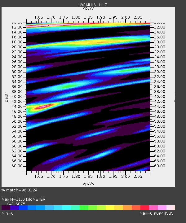
| Estimated Moho Depth: |
11.0 km |
| Estimated Crust Vp/Vs: |
1.69 |
| Assumed Crust Vp: |
6.566 km/s |
| Estimated Crust Vs: |
3.891 km/s |
| Estimated Crust Poisson's Ratio: |
0.23 |
|
| Radial Match: |
96.3124 % |
| Radial Bump: |
400 |
| Transverse Match: |
82.4119 % |
| Transverse Bump: |
400 |
| SOD ConfigId: |
30536071 |
| Insert Time: |
2023-07-16 11:07:32.706 +0000 |
| GWidth: |
2.5 |
| Max Bumps: |
400 |
| Tol: |
0.001 |
|

Signal To Noise
| Channel | StoN | STA | LTA |
| UW:MULN: :HHZ:20230702T10:39:01.179993Z | 21.676313 | 1.9524139E-6 | 9.00713E-8 |
| UW:MULN: :HHN:20230702T10:39:01.179993Z | 6.2822013 | 3.6340455E-7 | 5.784669E-8 |
| UW:MULN: :HHE:20230702T10:39:01.179993Z | 3.7148628 | 3.0461632E-7 | 8.1999346E-8 |
| Arrivals |
| Ps | 1.2 SECOND |
| PpPs | 4.4 SECOND |
| PsPs/PpSs | 5.6 SECOND |


