You are here: Home > Network List > UW - Pacific Northwest Regional Seismic Network Stations List
> Station PAN4H Panhandle 4H Camp, Shelton, WA, USA > Earthquake Result Viewer
PAN4H Panhandle 4H Camp, Shelton, WA, USA - Earthquake Result Viewer
| Earthquake location: |
Tonga Islands |
| Earthquake latitude/longitude: |
-17.9/-174.7 |
| Earthquake time(UTC): |
2023/07/02 (183) 10:27:45 GMT |
| Earthquake Depth: |
247 km |
| Earthquake Magnitude: |
6.7 Mi |
| Earthquake Catalog/Contributor: |
NEIC PDE/at |
|
| Network: |
UW Pacific Northwest Regional Seismic Network |
| Station: |
PAN4H Panhandle 4H Camp, Shelton, WA, USA |
| Lat/Lon: |
47.18 N/123.27 W |
| Elevation: |
132 m |
|
| Distance: |
79.5 deg |
| Az: |
32.847 deg |
| Baz: |
229.206 deg |
| Ray Param: |
0.048260093 |
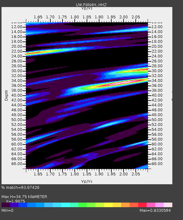
| Estimated Moho Depth: |
34.75 km |
| Estimated Crust Vp/Vs: |
1.99 |
| Assumed Crust Vp: |
6.566 km/s |
| Estimated Crust Vs: |
3.304 km/s |
| Estimated Crust Poisson's Ratio: |
0.33 |
|
| Radial Match: |
93.87428 % |
| Radial Bump: |
400 |
| Transverse Match: |
91.21147 % |
| Transverse Bump: |
400 |
| SOD ConfigId: |
30536071 |
| Insert Time: |
2023-07-16 11:07:57.122 +0000 |
| GWidth: |
2.5 |
| Max Bumps: |
400 |
| Tol: |
0.001 |
|

Signal To Noise
| Channel | StoN | STA | LTA |
| UW:PAN4H: :HHZ:20230702T10:38:53.23999Z | 18.36001 | 1.8607492E-6 | 1.0134794E-7 |
| UW:PAN4H: :HHN:20230702T10:38:53.23999Z | 4.6789107 | 3.769437E-7 | 8.056227E-8 |
| UW:PAN4H: :HHE:20230702T10:38:53.23999Z | 5.7892327 | 4.6964075E-7 | 8.112314E-8 |
| Arrivals |
| Ps | 5.4 SECOND |
| PpPs | 15 SECOND |
| PsPs/PpSs | 21 SECOND |


