You are here: Home > Network List > UW - Pacific Northwest Regional Seismic Network Stations List
> Station TNSKT Tonasket, WA, USA > Earthquake Result Viewer
TNSKT Tonasket, WA, USA - Earthquake Result Viewer
| Earthquake location: |
Tonga Islands |
| Earthquake latitude/longitude: |
-17.9/-174.7 |
| Earthquake time(UTC): |
2023/07/02 (183) 10:27:45 GMT |
| Earthquake Depth: |
247 km |
| Earthquake Magnitude: |
6.7 Mi |
| Earthquake Catalog/Contributor: |
NEIC PDE/at |
|
| Network: |
UW Pacific Northwest Regional Seismic Network |
| Station: |
TNSKT Tonasket, WA, USA |
| Lat/Lon: |
48.72 N/119.44 W |
| Elevation: |
395 m |
|
| Distance: |
82.5 deg |
| Az: |
33.288 deg |
| Baz: |
232.109 deg |
| Ray Param: |
0.04622703 |
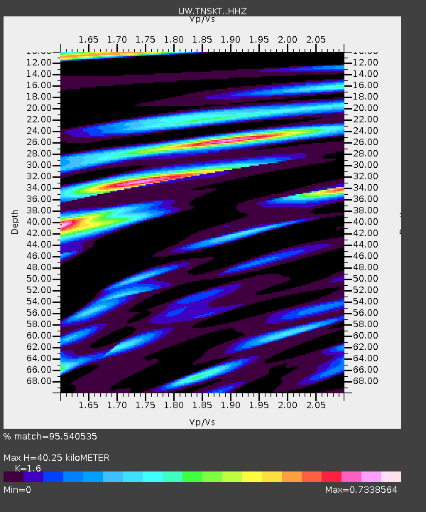
| Estimated Moho Depth: |
40.25 km |
| Estimated Crust Vp/Vs: |
1.60 |
| Assumed Crust Vp: |
6.419 km/s |
| Estimated Crust Vs: |
4.012 km/s |
| Estimated Crust Poisson's Ratio: |
0.18 |
|
| Radial Match: |
95.540535 % |
| Radial Bump: |
400 |
| Transverse Match: |
80.504944 % |
| Transverse Bump: |
400 |
| SOD ConfigId: |
30536071 |
| Insert Time: |
2023-07-16 11:08:48.649 +0000 |
| GWidth: |
2.5 |
| Max Bumps: |
400 |
| Tol: |
0.001 |
|

Signal To Noise
| Channel | StoN | STA | LTA |
| UW:TNSKT: :HHZ:20230702T10:39:08.799988Z | 28.305872 | 1.9794122E-6 | 6.9929385E-8 |
| UW:TNSKT: :HHN:20230702T10:39:08.799988Z | 3.7537212 | 5.257456E-7 | 1.4005983E-7 |
| UW:TNSKT: :HHE:20230702T10:39:08.799988Z | 4.4298773 | 5.139549E-7 | 1.1602012E-7 |
| Arrivals |
| Ps | 3.9 SECOND |
| PpPs | 16 SECOND |
| PsPs/PpSs | 20 SECOND |


