You are here: Home > Network List > UW - Pacific Northwest Regional Seismic Network Stations List
> Station TWISP Winthrop, WA, USA > Earthquake Result Viewer
TWISP Winthrop, WA, USA - Earthquake Result Viewer
| Earthquake location: |
Tonga Islands |
| Earthquake latitude/longitude: |
-17.9/-174.7 |
| Earthquake time(UTC): |
2023/07/02 (183) 10:27:45 GMT |
| Earthquake Depth: |
247 km |
| Earthquake Magnitude: |
6.7 Mi |
| Earthquake Catalog/Contributor: |
NEIC PDE/at |
|
| Network: |
UW Pacific Northwest Regional Seismic Network |
| Station: |
TWISP Winthrop, WA, USA |
| Lat/Lon: |
48.46 N/120.12 W |
| Elevation: |
756 m |
|
| Distance: |
82.0 deg |
| Az: |
33.215 deg |
| Baz: |
231.593 deg |
| Ray Param: |
0.04658412 |
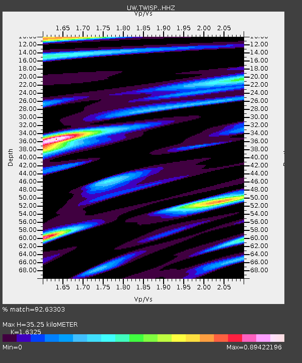
| Estimated Moho Depth: |
35.25 km |
| Estimated Crust Vp/Vs: |
1.63 |
| Assumed Crust Vp: |
6.566 km/s |
| Estimated Crust Vs: |
4.022 km/s |
| Estimated Crust Poisson's Ratio: |
0.20 |
|
| Radial Match: |
92.63303 % |
| Radial Bump: |
400 |
| Transverse Match: |
90.94391 % |
| Transverse Bump: |
400 |
| SOD ConfigId: |
30536071 |
| Insert Time: |
2023-07-16 11:08:58.878 +0000 |
| GWidth: |
2.5 |
| Max Bumps: |
400 |
| Tol: |
0.001 |
|

Signal To Noise
| Channel | StoN | STA | LTA |
| UW:TWISP: :HHZ:20230702T10:39:06.150024Z | 25.772547 | 1.8900645E-6 | 7.333635E-8 |
| UW:TWISP: :HHN:20230702T10:39:06.150024Z | 10.5107155 | 4.20185E-7 | 3.997682E-8 |
| UW:TWISP: :HHE:20230702T10:39:06.150024Z | 11.847917 | 4.4422717E-7 | 3.7494118E-8 |
| Arrivals |
| Ps | 3.5 SECOND |
| PpPs | 14 SECOND |
| PsPs/PpSs | 17 SECOND |


