You are here: Home > Network List > WW - Idaho Seismic Network () Stations List
> Station BILL Emerald Creek, Idaho > Earthquake Result Viewer
BILL Emerald Creek, Idaho - Earthquake Result Viewer
| Earthquake location: |
Tonga Islands |
| Earthquake latitude/longitude: |
-17.9/-174.7 |
| Earthquake time(UTC): |
2023/07/02 (183) 10:27:45 GMT |
| Earthquake Depth: |
247 km |
| Earthquake Magnitude: |
6.7 Mi |
| Earthquake Catalog/Contributor: |
NEIC PDE/at |
|
| Network: |
WW Idaho Seismic Network () |
| Station: |
BILL Emerald Creek, Idaho |
| Lat/Lon: |
47.03 N/116.34 W |
| Elevation: |
866 m |
|
| Distance: |
83.2 deg |
| Az: |
35.91 deg |
| Baz: |
234.732 deg |
| Ray Param: |
0.04575571 |
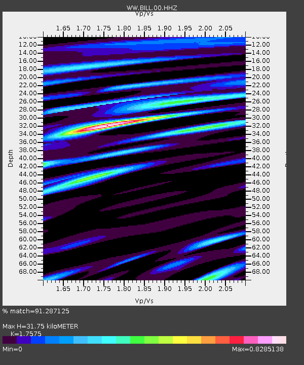
| Estimated Moho Depth: |
31.75 km |
| Estimated Crust Vp/Vs: |
1.76 |
| Assumed Crust Vp: |
6.571 km/s |
| Estimated Crust Vs: |
3.739 km/s |
| Estimated Crust Poisson's Ratio: |
0.26 |
|
| Radial Match: |
91.287125 % |
| Radial Bump: |
400 |
| Transverse Match: |
89.43139 % |
| Transverse Bump: |
400 |
| SOD ConfigId: |
30536071 |
| Insert Time: |
2023-07-16 11:09:40.114 +0000 |
| GWidth: |
2.5 |
| Max Bumps: |
400 |
| Tol: |
0.001 |
|
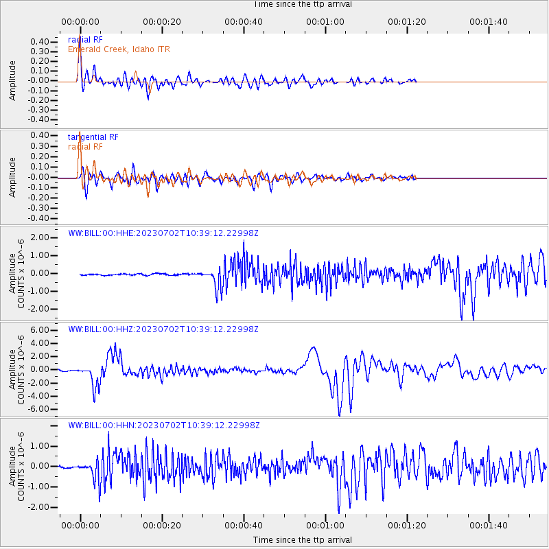
Signal To Noise
| Channel | StoN | STA | LTA |
| WW:BILL:00:HHZ:20230702T10:39:12.22998Z | 20.311747 | 1.8010692E-6 | 8.867131E-8 |
| WW:BILL:00:HHN:20230702T10:39:12.22998Z | 16.497375 | 4.680268E-7 | 2.8369774E-8 |
| WW:BILL:00:HHE:20230702T10:39:12.22998Z | 14.516766 | 5.790707E-7 | 3.9889784E-8 |
| Arrivals |
| Ps | 3.8 SECOND |
| PpPs | 13 SECOND |
| PsPs/PpSs | 17 SECOND |


