You are here: Home > Network List > BK - Berkeley Digital Seismograph Network Stations List
> Station SAO San Andreas Geophysical Obs., Hollister, CA, USA > Earthquake Result Viewer
SAO San Andreas Geophysical Obs., Hollister, CA, USA - Earthquake Result Viewer

| Earthquake location: |
Vanuatu Islands |
| Earthquake latitude/longitude: |
-13.7/166.6 |
| Earthquake time(UTC): |
2010/05/27 (147) 17:14:46 GMT |
| Earthquake Depth: |
31 km |
| Earthquake Magnitude: |
6.2 MB, 7.1 MS, 7.1 MW, 7.0 MW |
| Earthquake Catalog/Contributor: |
WHDF/NEIC |
|
| Network: |
BK Berkeley Digital Seismograph Network |
| Station: |
SAO San Andreas Geophysical Obs., Hollister, CA, USA |
| Lat/Lon: |
36.76 N/121.45 W |
| Elevation: |
317 m |
|
| Distance: |
84.1 deg |
| Az: |
50.116 deg |
| Baz: |
248.238 deg |
| Ray Param: |
0.0456547 |
| Estimated Moho Depth: |
27.25 km |
| Estimated Crust Vp/Vs: |
1.60 |
| Assumed Crust Vp: |
6.391 km/s |
| Estimated Crust Vs: |
3.994 km/s |
| Estimated Crust Poisson's Ratio: |
0.18 |
|
| Radial Match: |
92.20017 % |
| Radial Bump: |
400 |
| Transverse Match: |
80.73923 % |
| Transverse Bump: |
400 |
| SOD ConfigId: |
314592 |
| Insert Time: |
2010-09-14 07:23:01.605 +0000 |
| GWidth: |
2.5 |
| Max Bumps: |
400 |
| Tol: |
0.001 |
|
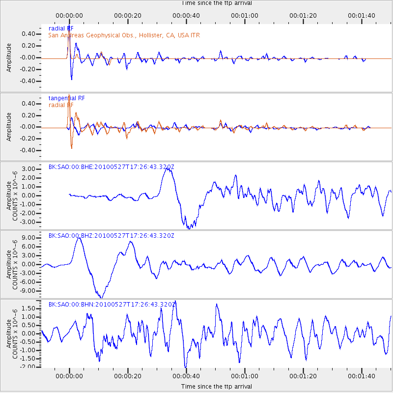
Signal To Noise
| Channel | StoN | STA | LTA |
| BK:SAO:00:BHZ:20100527T17:26:43.320Z | 25.842953 | 6.095419E-6 | 2.3586387E-7 |
| BK:SAO:00:BHN:20100527T17:26:43.320Z | 1.5195111 | 4.1256402E-7 | 2.7151103E-7 |
| BK:SAO:00:BHE:20100527T17:26:43.320Z | 11.870171 | 2.142464E-6 | 1.8049143E-7 |
| Arrivals |
| Ps | 2.6 SECOND |
| PpPs | 11 SECOND |
| PsPs/PpSs | 13 SECOND |


