You are here: Home > Network List > GT - Global Telemetered Seismograph Network (USAF/USGS) Stations List
> Station LPAZ La Paz , Bolivia > Earthquake Result Viewer
LPAZ La Paz , Bolivia - Earthquake Result Viewer

| Earthquake location: |
Southern East Pacific Rise |
| Earthquake latitude/longitude: |
-56.2/-122.0 |
| Earthquake time(UTC): |
2018/11/15 (319) 23:09:01 GMT |
| Earthquake Depth: |
10 km |
| Earthquake Magnitude: |
6.3 Mww |
| Earthquake Catalog/Contributor: |
NEIC PDE/us |
|
| Network: |
GT Global Telemetered Seismograph Network (USAF/USGS) |
| Station: |
LPAZ La Paz , Bolivia |
| Lat/Lon: |
16.17 S/68.08 W |
| Elevation: |
4817 m |
|
| Distance: |
57.0 deg |
| Az: |
67.969 deg |
| Baz: |
212.589 deg |
| Ray Param: |
0.063802175 |
| Estimated Moho Depth: |
25.5 km |
| Estimated Crust Vp/Vs: |
1.81 |
| Assumed Crust Vp: |
6.454 km/s |
| Estimated Crust Vs: |
3.571 km/s |
| Estimated Crust Poisson's Ratio: |
0.28 |
|
| Radial Match: |
84.707 % |
| Radial Bump: |
400 |
| Transverse Match: |
82.875854 % |
| Transverse Bump: |
400 |
| SOD ConfigId: |
3165032 |
| Insert Time: |
2018-11-29 23:15:46.211 +0000 |
| GWidth: |
2.5 |
| Max Bumps: |
400 |
| Tol: |
0.001 |
|
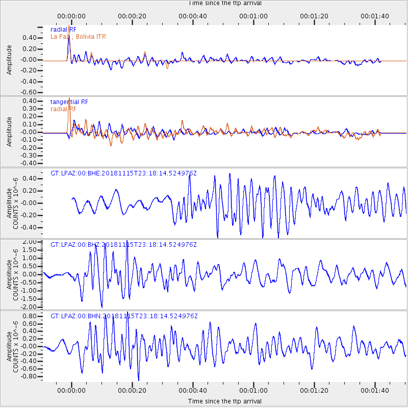
Signal To Noise
| Channel | StoN | STA | LTA |
| GT:LPAZ:00:BHZ:20181115T23:18:14.524976Z | 7.649855 | 5.7925354E-7 | 7.572085E-8 |
| GT:LPAZ:00:BHN:20181115T23:18:14.524976Z | 4.2953796 | 2.739127E-7 | 6.376914E-8 |
| GT:LPAZ:00:BHE:20181115T23:18:14.524976Z | 1.6283318 | 1.5315126E-7 | 9.405409E-8 |
| Arrivals |
| Ps | 3.4 SECOND |
| PpPs | 11 SECOND |
| PsPs/PpSs | 14 SECOND |


