You are here: Home > Network List > IU - Global Seismograph Network (GSN - IRIS/USGS) Stations List
> Station QSPA South Pole Remote Earth Science Observatory (Quiet Zone) > Earthquake Result Viewer
QSPA South Pole Remote Earth Science Observatory (Quiet Zone) - Earthquake Result Viewer
| Earthquake location: |
Southern East Pacific Rise |
| Earthquake latitude/longitude: |
-56.2/-122.0 |
| Earthquake time(UTC): |
2018/11/15 (319) 23:09:01 GMT |
| Earthquake Depth: |
10 km |
| Earthquake Magnitude: |
6.3 Mww |
| Earthquake Catalog/Contributor: |
NEIC PDE/us |
|
| Network: |
IU Global Seismograph Network (GSN - IRIS/USGS) |
| Station: |
QSPA South Pole Remote Earth Science Observatory (Quiet Zone) |
| Lat/Lon: |
89.93 S/144.44 E |
| Elevation: |
2850 m |
|
| Distance: |
33.9 deg |
| Az: |
180.128 deg |
| Baz: |
93.626 deg |
| Ray Param: |
0.07797401 |
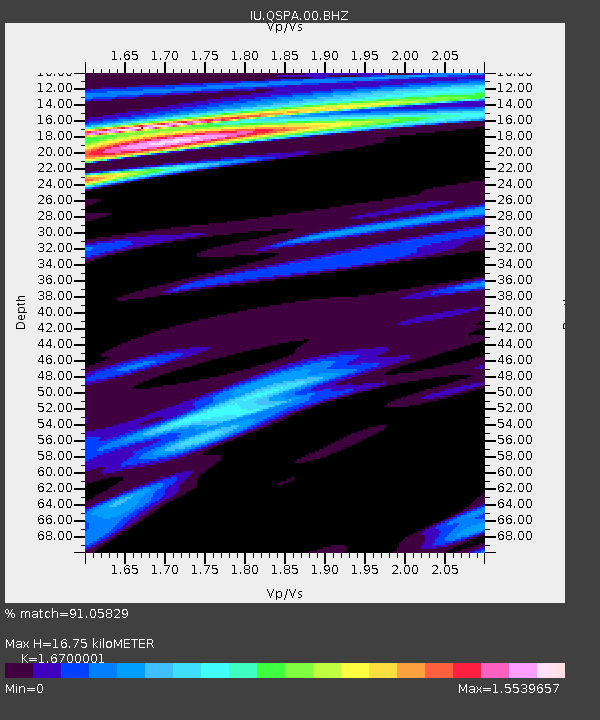
| Estimated Moho Depth: |
16.75 km |
| Estimated Crust Vp/Vs: |
1.67 |
| Assumed Crust Vp: |
6.193 km/s |
| Estimated Crust Vs: |
3.708 km/s |
| Estimated Crust Poisson's Ratio: |
0.22 |
|
| Radial Match: |
91.05829 % |
| Radial Bump: |
400 |
| Transverse Match: |
77.902145 % |
| Transverse Bump: |
400 |
| SOD ConfigId: |
3165032 |
| Insert Time: |
2018-11-29 23:16:09.407 +0000 |
| GWidth: |
2.5 |
| Max Bumps: |
400 |
| Tol: |
0.001 |
|

Signal To Noise
| Channel | StoN | STA | LTA |
| IU:QSPA:00:BHZ:20181115T23:15:13.668988Z | 3.0160577 | 5.23263E-7 | 1.7349237E-7 |
| IU:QSPA:00:BH1:20181115T23:15:13.668988Z | 0.5712547 | 7.2381646E-8 | 1.2670644E-7 |
| IU:QSPA:00:BH2:20181115T23:15:13.668988Z | 2.5546083 | 3.018048E-7 | 1.18141315E-7 |
| Arrivals |
| Ps | 2.0 SECOND |
| PpPs | 6.7 SECOND |
| PsPs/PpSs | 8.6 SECOND |


