You are here: Home > Network List > CI - Caltech Regional Seismic Network Stations List
> Station TUQ Turquiose Mountain, Baker, CA, USA > Earthquake Result Viewer
TUQ Turquiose Mountain, Baker, CA, USA - Earthquake Result Viewer
| Earthquake location: |
Vanuatu Islands |
| Earthquake latitude/longitude: |
-13.7/166.6 |
| Earthquake time(UTC): |
2010/05/27 (147) 17:14:46 GMT |
| Earthquake Depth: |
31 km |
| Earthquake Magnitude: |
6.2 MB, 7.1 MS, 7.1 MW, 7.0 MW |
| Earthquake Catalog/Contributor: |
WHDF/NEIC |
|
| Network: |
CI Caltech Regional Seismic Network |
| Station: |
TUQ Turquiose Mountain, Baker, CA, USA |
| Lat/Lon: |
35.44 N/115.92 W |
| Elevation: |
1350 m |
|
| Distance: |
87.9 deg |
| Az: |
52.899 deg |
| Baz: |
251.674 deg |
| Ray Param: |
0.042957142 |
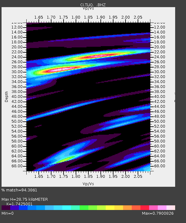
| Estimated Moho Depth: |
28.75 km |
| Estimated Crust Vp/Vs: |
1.74 |
| Assumed Crust Vp: |
6.276 km/s |
| Estimated Crust Vs: |
3.602 km/s |
| Estimated Crust Poisson's Ratio: |
0.25 |
|
| Radial Match: |
94.3861 % |
| Radial Bump: |
400 |
| Transverse Match: |
79.227264 % |
| Transverse Bump: |
400 |
| SOD ConfigId: |
314592 |
| Insert Time: |
2010-09-14 07:27:28.286 +0000 |
| GWidth: |
2.5 |
| Max Bumps: |
400 |
| Tol: |
0.001 |
|
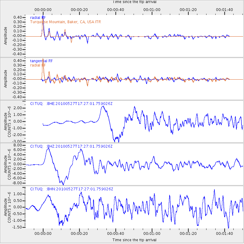
Signal To Noise
| Channel | StoN | STA | LTA |
| CI:TUQ: :BHZ:20100527T17:27:01.759026Z | 57.758453 | 4.470762E-6 | 7.7404465E-8 |
| CI:TUQ: :BHN:20100527T17:27:01.759026Z | 4.8476114 | 6.3978507E-7 | 1.3197945E-7 |
| CI:TUQ: :BHE:20100527T17:27:01.759026Z | 8.243679 | 1.6165678E-6 | 1.9609786E-7 |
| Arrivals |
| Ps | 3.5 SECOND |
| PpPs | 12 SECOND |
| PsPs/PpSs | 16 SECOND |


